Cova dels Segarulls.jpg
From Underfoot
File:Cova dels Segarulls.jpg

Size of this preview: 800 × 533 pixels. Other resolutions: 320 × 213 pixels | 640 × 427 pixels | 1,024 × 683 pixels | 1,280 × 853 pixels | 2,560 × 1,707 pixels | 4,608 × 3,072 pixels.
Original file (4,608 × 3,072 pixels, file size: 4.04 MB, MIME type: image/jpeg)
Summary
| Description |
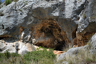
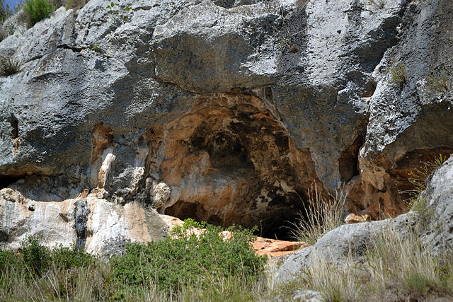
Català: La Cova dels Segarulls, Cova de les Pintures o Cova del Fondal de la Seguera, és una cova natural amb representació de pintura rupestre i enterrament col·lectiu d'incineració i inhumació. Està protegida com Patrimoni de la Humanitat en el conjunt de l'Art rupestre de l'arc mediterrani de la península Ibèrica. Està situada en els relleus meridionals del massís de Garraf, en el torrent del Fondo de la Seguera, a 3 km al sud de Vilafranca del Penedès, en el terme municipal d'Olèrdola (Alt Penedès).
|
||
| Date | |||
| Source | Own work | ||
| Author | Cilindr0 |
| Camera location | | View this and other nearby images on: OpenStreetMap |
|---|
Licensing
I, the copyright holder of this work, hereby publish it under the following licence:
This file is licensed under the Creative Commons Attribution-Share Alike 3.0 Spain licence.
- You are free:
- to share – to copy, distribute and transmit the work
- to remix – to adapt the work
- Under the following conditions:
- attribution – You must give appropriate credit, provide a link to the licence, and indicate if changes were made. You may do so in any reasonable manner, but not in any way that suggests the licensor endorses you or your use.
- share alike – If you remix, transform, or build upon the material, you must distribute your contributions under the same or compatible licence as the original.


|
This image was uploaded as part of Wiki Loves Monuments 2014.
|
File history
Click on a date/time to view the file as it appeared at that time.
| Date/Time | Thumbnail | Dimensions | User | Comment | |
|---|---|---|---|---|---|
| current | 15:09, 27 September 2014 | | 4,608 × 3,072 (4.04 MB) | wikimediacommons>Cilindr0 | User created page with UploadWizard |
File usage
The following page uses this file: