Dennert-Tanne Wennsglückt.jpg
From Underfoot

Size of this preview: 450 × 600 pixels. Other resolutions: 180 × 240 pixels | 360 × 480 pixels | 576 × 768 pixels | 768 × 1,024 pixels | 2,304 × 3,072 pixels.
Original file (2,304 × 3,072 pixels, file size: 368 KB, MIME type: image/jpeg)
Summary
| Description |
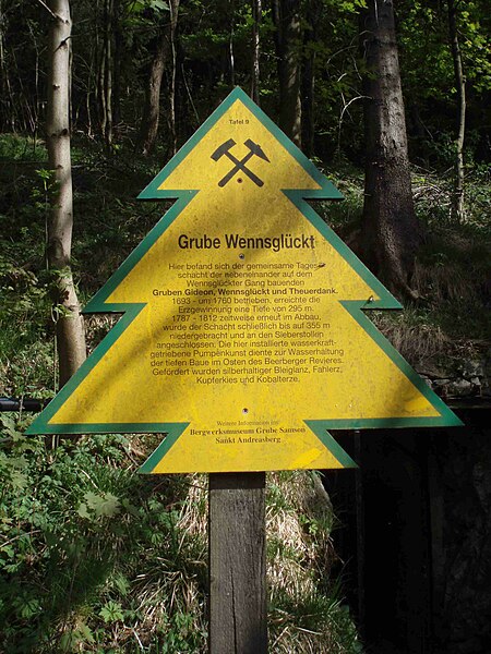
English: Dennert Fir Tree № 9, Wennsglückt (lit: if lucky) pit, Sankt Andreasberg, Lower Saxony, Germany. |
| Inscription | Grube Wennsglückt Hier befand sich der gemeinsame Tages- schacht der nebeneinander auf dem Wennsglückter Gang bauenden Gruben Gideon, Wennsglückt und Theuerdank. 1693 – um 1760 betrieben, erreichte die Erzgewinnung einer Tiefe von 295 m. 1787 – 1812 zweitweise erneut im Abbau, wurde der Schacht schließlich bis auf 355 m niedergebracht und an den Sieberstollen angeschlossen. Die hier installierte wasserkraft- getriebene Pumpenkunst diente zur Wasserhaltung der tiefen Baue im Osten des Beerberger Revieres. Gefördert wurden silberhaltiger Bleiglanz, Fahlerz, Kupferkies und Kobalterze. |
| Date | |
| Source | Own work |
| Author | Hejkal |
| Object location | | View this and other nearby images on: OpenStreetMap |
|---|
Licensing
This file is licensed under the Creative Commons Attribution-Share Alike 2.0 Germany licence.
- You are free:
- to share – to copy, distribute and transmit the work
- to remix – to adapt the work
- Under the following conditions:
- attribution – You must give appropriate credit, provide a link to the licence, and indicate if changes were made. You may do so in any reasonable manner, but not in any way that suggests the licensor endorses you or your use.
- share alike – If you remix, transform, or build upon the material, you must distribute your contributions under the same or compatible licence as the original.

Original upload log
(All user names refer to de.wikipedia)
- 2007-05-06 16:05 Hejkal 2304×3072×8 (376667 bytes) {{Information |Beschreibung = Grube Wennsglückt |Quelle = selbst fotografiert |Urheber = [[Benutzer:Hejkal]] |Datum = 5. Mai 2007 |Genehmigung = |Andere Versionen = |Anmerkungen = }}
File history
Click on a date/time to view the file as it appeared at that time.
| Date/Time | Thumbnail | Dimensions | User | Comment | |
|---|---|---|---|---|---|
| current | 16:51, 6 May 2007 | | 2,304 × 3,072 (368 KB) | wikimediacommons>Netnet | {{Information |Description=Grube Wennsglückt |Source=own photo |Date=2007-05-05 |Author=Original uploader was Hejkal at [http://de.wikipedia.org de.wikipedia] |Permission=CC-BY-SA-2.0-DE. |other_versions= }} {{Cc-by-sa-2.0-de}} == O |
File usage
There are no pages that use this file.