Ferfay - Fosse n° 2 - 2 bis des mines de Ferfay (09).JPG
From Underfoot
Original file (3,648 × 2,736 pixels, file size: 4.38 MB, MIME type: image/jpeg)
This file is from Wikimedia Commons and may be used by other projects. The description on its file description page there is shown below.
Summary
| DescriptionFerfay - Fosse n° 2 - 2 bis des mines de Ferfay (09).JPG |
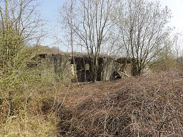
Français : La fosse n° 2 - 2 bis de la Compagnie des mines de Ferfay, devenue la Fosse Lahure de la Compagnie des mines de Marles, était un charbonnage constitué de deux puits situé à Ferfay, Pas-de-Calais, Nord-Pas-de-Calais, France. |
|||||||||||||||||||||||
| Date | ||||||||||||||||||||||||
| Source | Own work | |||||||||||||||||||||||
| Author |
creator QS:P170,Q58229383 |
|||||||||||||||||||||||
| Permission (Reusing this file) |
|
|||||||||||||||||||||||
| Camera location | 50° 31′ 19.98″ N, 2° 26′ 18.51″ E | View this and other nearby images on: OpenStreetMap |
|---|
Captions
Items portrayed in this file
depicts
28 March 2012
50°31'19.9800001"N, 2°26'18.5150000"E
0.00625 second
4.25 millimetre
125
File history
Click on a date/time to view the file as it appeared at that time.
| Date/Time | Thumbnail | Dimensions | User | Comment | |
|---|---|---|---|---|---|
| current | 13:57, 29 March 2012 | 3,648 × 2,736 (4.38 MB) | wikimediacommons>Jérémy-Günther-Heinz Jähnick |
File usage
There are no pages that use this file.
Metadata
This file contains additional information, probably added from the digital camera or scanner used to create or digitise it.
If the file has been modified from its original state, some details may not fully reflect the modified file.
| Camera manufacturer | SONY |
|---|---|
| Camera model | DSC-HX5V |
| Exposure time | 1/160 sec (0.00625) |
| F Number | f/8 |
| ISO speed rating | 125 |
| Date and time of data generation | 14:27, 28 March 2012 |
| Lens focal length | 4.25 mm |
| Latitude | 50° 31′ 19.98″ N |
| Longitude | 2° 26′ 18.52″ E |
| Altitude | 72.8 metres above sea level |
| Orientation | Normal |
| Horizontal resolution | 72 dpi |
| Vertical resolution | 72 dpi |
| File change date and time | 14:27, 28 March 2012 |
| Y and C positioning | Co-sited |
| Exposure Program | Normal program |
| Exif version | 2.21 |
| Date and time of digitising | 14:27, 28 March 2012 |
| Meaning of each component |
|
| Image compression mode | 4 |
| APEX exposure bias | 0 |
| Maximum land aperture | 3.625 APEX (f/3.51) |
| Metering mode | Pattern |
| Light source | Unknown |
| Flash | Flash did not fire, auto mode |
| Supported Flashpix version | 1 |
| Colour space | sRGB |
| File source | Digital still camera |
| Scene type | A directly photographed image |
| Custom image processing | Normal process |
| Exposure mode | Auto exposure |
| White balance | Auto white balance |
| Scene capture type | Landscape |
| Contrast | Normal |
| Saturation | Normal |
| Sharpness | Normal |
| GPS time (atomic clock) | 12:27 |
| Receiver status | Measurement in progress |
| Measurement mode | 3-dimensional measurement |
| Speed unit | Kilometres per hour |
| Speed of GPS receiver | 1.5 |
| Reference for direction of movement | True direction |
| Direction of movement | 153.22 |
| Reference for direction of image | Magnetic direction |
| Direction of image | 108.25 |
| Geodetic survey data used | WGS-84 |
| GPS date | 28 March 2012 |
| GPS differential correction | 0 |
| GPS tag version | 0.0.2.2 |