Fosse Sabatier.JPG
From Underfoot

Size of this preview: 800 × 565 pixels. Other resolutions: 320 × 226 pixels | 640 × 452 pixels | 945 × 667 pixels.
Original file (945 × 667 pixels, file size: 141 KB, MIME type: image/jpeg)
Summary
| Description |
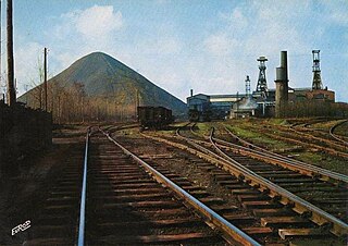
Français : La fosse Sabatier de la Compagnie des mines d'Anzin était un charbonnage constitué de deux puits situé à Raismes, Nord, Nord-Pas-de-Calais, France. |
| Date | between 1975 and 1980 |
| Source |
Français : Charbonnages de France |
| Author | Unknown author |
| Permission (Reusing this file) |
This file is licensed under the Creative Commons Attribution 1.0 Generic licence. Attribution: Charbonnages de France
|

|
Attribution information, such as the author's name, e-mail, website, or signature, that was once visible in the image itself has been moved into the image metadata and/or image description page. This makes the image easier to reuse and more language-neutral, and makes the text easier to process and search for. Commons discourages placing visible author information in images.
|
| Object location | | View this and other nearby images on: OpenStreetMap |
|---|
File history
Click on a date/time to view the file as it appeared at that time.
| Date/Time | Thumbnail | Dimensions | User | Comment | |
|---|---|---|---|---|---|
| current | 15:30, 13 May 2025 | | 945 × 667 (141 KB) | wikimediacommons>Vysotsky | watermark removed |
File usage
There are no pages that use this file.