Markelsheim Lochbach Verdolung 02.jpg
From Underfoot

Size of this preview: 800 × 533 pixels. Other resolutions: 320 × 213 pixels | 640 × 427 pixels | 1,024 × 683 pixels | 1,280 × 853 pixels | 2,560 × 1,707 pixels | 4,500 × 3,000 pixels.
Original file (4,500 × 3,000 pixels, file size: 6.88 MB, MIME type: image/jpeg)
Summary
| Description |
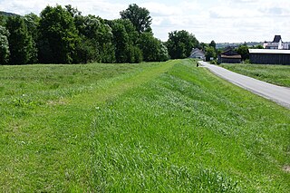
Deutsch: Lochbach (Tauber) in Markelsheim, Verdolung (Bypass) zur Umleitung der Mündung des Bachs bei Hochwasser, als Wall in der Landschaft erkennbar
English: Lochbach (Tauber) in Markelsheim, drain, bypass for flood protection, visible as a rampart |
| Date | |
| Source | Own work |
| Author | Hubert Berberich (HubiB) |
| Permission (Reusing this file) |
Foto: Hubert Berberich Wikimedia Commons (CC-BY-4.0) Deutsch: Das Bild ist bewusst so fotografiert. Falls Du es hier in Commons ändern willst, ändere bitte nicht dieses Bild, sondern lege eine Kopie an, die sich auf dieses Bild bezieht!
English: This picture is deliberately made the way it is. If you want to change it here in Commons, please do not change this picture, but make a copy referring to this picture! |
| Camera location | | View this and other nearby images on: OpenStreetMap |
|---|
Licensing
This file is licensed under the Creative Commons Attribution 4.0 International licence.
- You are free:
- to share – to copy, distribute and transmit the work
- to remix – to adapt the work
- Under the following conditions:
- attribution – You must give appropriate credit, provide a link to the licence, and indicate if changes were made. You may do so in any reasonable manner, but not in any way that suggests the licensor endorses you or your use.
File history
Click on a date/time to view the file as it appeared at that time.
| Date/Time | Thumbnail | Dimensions | User | Comment | |
|---|---|---|---|---|---|
| current | 17:56, 1 August 2021 | | 4,500 × 3,000 (6.88 MB) | wikimediacommons>HubiB | == {{int:filedesc}} == {{Information |Description = {{de|Lochbach (Tauber) in Markelsheim, Verdolung (Bypass) zur Umleitung der Mündung des Bachs bei Hochwasser, als Wall in der Landschaft erkennbar}} {{en|Lochbach (Tauber) in Markelsheim, drain, bypass for flood protection, visible as a rampart}} |Source = {{Own}} |Date = 2021-07-31 |Author = Hubert Berberich (HubiB) |Permission = Foto: Hubert Berberich Wikimedia Commons (CC-BY-4.0) {{de|Das Bild ist bewusst so fotografiert. F... |
File usage
There are no pages that use this file.