Merville Gun Battery (6818465782).jpg
From Underfoot

Size of this preview: 800 × 600 pixels. Other resolutions: 320 × 240 pixels | 640 × 480 pixels | 1,024 × 768 pixels | 1,280 × 960 pixels | 2,592 × 1,944 pixels.
Original file (2,592 × 1,944 pixels, file size: 1.51 MB, MIME type: image/jpeg)
.jpg)
Summary
| Description |
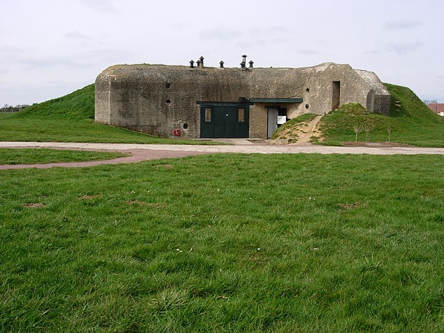
The Merville Gun Battery was a coastal fortification in Normandy, France, in use as part of the Nazis' Atlantic Wall built to defend continental Europe from Allied invasion. It was a particularly heavily fortified position and one of the first places to be attacked by Allied forces during the Normandy Landings commonly known as D-Day. http://www.1940.co.uk/history/article/merville/merville.htm |
| Date | |
| Source | Merville Gun Battery |
| Author | Richard Matthews from London, England |
| Camera location | | View this and other nearby images on: OpenStreetMap |
|---|
.jpg¶ms=049.269586_N_-000.196442_E_globe:Earth_type:camera_source:Flickr_&language=en-gb)
Licensing
This file is licensed under the Creative Commons Attribution 2.0 Generic licence.
- You are free:
- to share – to copy, distribute and transmit the work
- to remix – to adapt the work
- Under the following conditions:
- attribution – You must give appropriate credit, provide a link to the licence, and indicate if changes were made. You may do so in any reasonable manner, but not in any way that suggests the licensor endorses you or your use.
| This image was originally posted to Flickr by Richard_of_England at https://flickr.com/photos/57827564@N03/6818465782 (archive). It was reviewed on 5 June 2019 by FlickreviewR 2 and was confirmed to be licensed under the terms of the cc-by-2.0. |
File history
Click on a date/time to view the file as it appeared at that time.
| Date/Time | Thumbnail | Dimensions | User | Comment | |
|---|---|---|---|---|---|
| current | 07:56, 5 June 2019 | | 2,592 × 1,944 (1.51 MB) | wikimediacommons>Sleske | Transferred from Flickr via #flickr2commons |
File usage
There are no pages that use this file.
.jpg)