Muggendorf - Myralucke, Infotafel.JPG
From Underfoot

Size of this preview: 800 × 551 pixels. Other resolutions: 320 × 220 pixels | 640 × 441 pixels | 1,024 × 705 pixels | 1,280 × 882 pixels | 2,560 × 1,763 pixels | 4,603 × 3,170 pixels.
Original file (4,603 × 3,170 pixels, file size: 8.37 MB, MIME type: image/jpeg)
Summary
| Description |
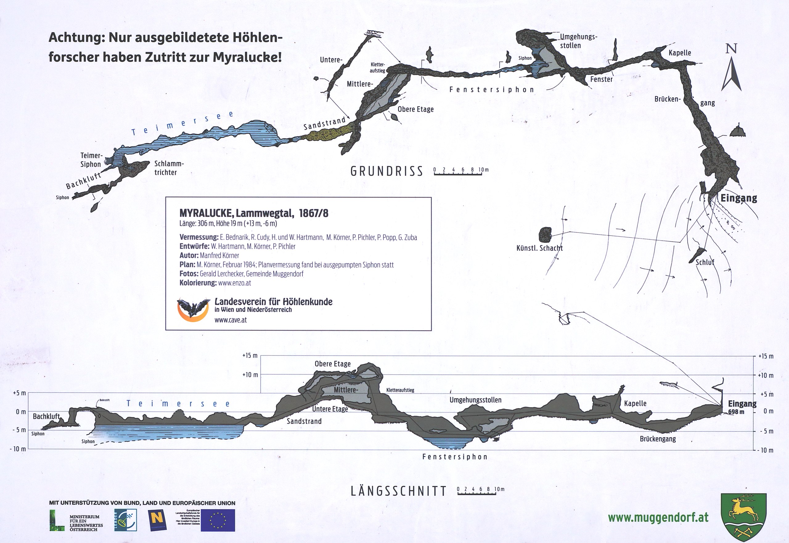
Deutsch: Infotafel über die Myralucke in der niederösterreichischen Gemeinde Muggendorf. Die Tafel ist öffentlich zugänglich und befindet sich unmittelbar vor der Myralucke im Lamwegtal. |
| Date | |
| Source | Own work |
| Author | C.Stadler/Bwag |
| Permission (Reusing this file) |
Deutsch: Hallo, du darfst meine Fotos kostenlos nutzen, aber nenne mich bitte als Fotograf, beispielsweise „Foto: C.Stadler/Bwag“ oder © C.Stadler/Bwag; CC-BY-SA-4.0. Auf mehr Angaben bestehe ich nicht - im Gegensatz zu manch anderen, die die Vorgaben der unten angeführten Lizenzierung auf Punkt und Beistrich einfordern. English: Feel free to use my photos, but please mention me as the author like © C.Stadler/Bwag or © C.Stadler/Bwag; CC-BY-SA-4.0 (that's good enough) and if you want send me a message: bwag@gmx.net. |
| Object location | | View this and other nearby images on: OpenStreetMap |
|---|
| Camera location | | View this and other nearby images on: OpenStreetMap |
|---|
Licensing
|
Freedom of Panorama This picture of an otherwise copyrighted work may be distributed under the conditions of § 54 (1) Z. 5 of the Austrian copyright law which allows to reproduce, distribute, and publish architectural works of an actual building or other works of visual arts which were created to permanently remain at a public place. Note: Due to the principle of Lex loci protectionis, this applies only to reuse of this picture in Austria. Reuse in other countries is subject to local law. Further information can be found on Commons and in German Wikipedia.
|
I, the copyright holder of this work, hereby publish it under the following licence:
This file is licensed under the Creative Commons Attribution-Share Alike 4.0 International licence.
- You are free:
- to share – to copy, distribute and transmit the work
- to remix – to adapt the work
- Under the following conditions:
- attribution – You must give appropriate credit, provide a link to the licence, and indicate if changes were made. You may do so in any reasonable manner, but not in any way that suggests the licensor endorses you or your use.
- share alike – If you remix, transform, or build upon the material, you must distribute your contributions under the same or compatible licence as the original.
File history
Click on a date/time to view the file as it appeared at that time.
| Date/Time | Thumbnail | Dimensions | User | Comment | |
|---|---|---|---|---|---|
| current | 10:22, 4 January 2020 | | 4,603 × 3,170 (8.37 MB) | wikimediacommons>Bwag | b |
File usage
There are no pages that use this file.