NSG Schultheis-Weiher.jpg
From Underfoot

Size of this preview: 800 × 450 pixels. Other resolutions: 320 × 180 pixels | 640 × 360 pixels | 1,024 × 576 pixels | 1,280 × 720 pixels | 2,560 × 1,440 pixels | 4,000 × 2,250 pixels.
Original file (4,000 × 2,250 pixels, file size: 4.45 MB, MIME type: image/jpeg)
Summary
| Description |
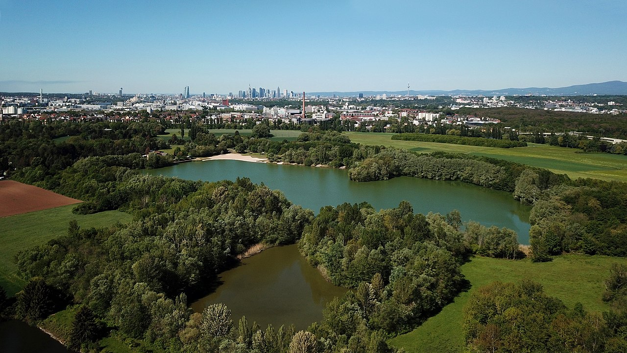
Deutsch: (NSG:HE-1413001)_Rumpenheimer und Bürgeler Kiesgruben - der Schultheis-Weiher: der linke Teil ist öffentlicher Badesee mit Strand, der rechte Teil sowie der kleine See im Vordergrund stehen unter Naturschutz und dürfen nicht betreten werden. Ganz links in der Ecke ist ein Feuerlöschteich. Am Horizont die Skyline von Frankfurt.
English: (NSG:HE-1413001)_Rumpenheimer und Bürgeler Kiesgruben - Lake "Schultheis-Weiher": the left part is a public swimming lake with beach, the right part and the small lake in the front are nature reserve and must not be entered. On the left side there is a pond for fire extinguishing. In the background the skyline of Frankfurt. |
| Date | |
| Source | Own work |
| Author | Plenz |
| Camera location | | View this and other nearby images on: OpenStreetMap |
|---|
Aufgenommen mit einem DJI Mavic Pro, ca. 90 m vom Naturschutzgebiet entfernt und in 100 m Höhe. Das Foto wurde anschließend bearbeitet und die Weitwinkelverzerrung beseitigt.
Photo made by a DJI Mavic Pro, 90 m away from the nature reserve and from 100 m height. Wide-angle distortion manually removed.
Licensing
I, the copyright holder of this work, hereby publish it under the following licence:
This file is licensed under the Creative Commons Attribution-Share Alike 4.0 International licence.
- You are free:
- to share – to copy, distribute and transmit the work
- to remix – to adapt the work
- Under the following conditions:
- attribution – You must give appropriate credit, provide a link to the licence, and indicate if changes were made. You may do so in any reasonable manner, but not in any way that suggests the licensor endorses you or your use.
- share alike – If you remix, transform, or build upon the material, you must distribute your contributions under the same or compatible licence as the original.
This image was uploaded as part of Wiki Loves Earth 2019.
|
 |
File history
Click on a date/time to view the file as it appeared at that time.
| Date/Time | Thumbnail | Dimensions | User | Comment | |
|---|---|---|---|---|---|
| current | 21:30, 15 May 2019 | | 4,000 × 2,250 (4.45 MB) | wikimediacommons>Plenz | User created page with UploadWizard |
File usage
There are no pages that use this file.