Topografia de la cova del Salomó (1964).jpg
From Underfoot

No higher resolution available.
Topografia_de_la_cova_del_Salomó_(1964).jpg (742 × 542 pixels, file size: 58 KB, MIME type: image/jpeg)
.jpg)
Summary
| Description |
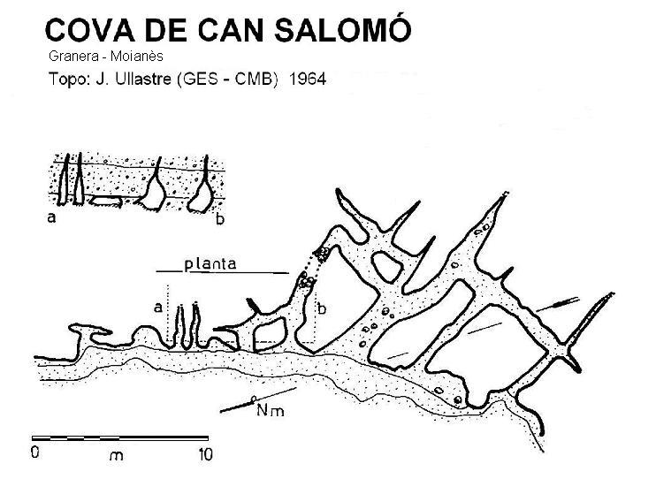
Català: Mapa topogràfic de la cova del Salomó, a Granera. Fet per J. Ullastre, del Grup d'Exploracions Subterrànies del Club Muntanyenc Barcelonès, el 1964. |
| Date | |
| Source | https://espeleoindex.com/files/1fe305_salomo.JPG |
| Author | J. Ullastre (Grup d'Exploracions Subterrànies, Club Muntanyenc Barcelonès) |
Licensing
This file is licensed under the Creative Commons Attribution-Share Alike 4.0 International licence.
- You are free:
- to share – to copy, distribute and transmit the work
- to remix – to adapt the work
- Under the following conditions:
- attribution – You must give appropriate credit, provide a link to the licence, and indicate if changes were made. You may do so in any reasonable manner, but not in any way that suggests the licensor endorses you or your use.
- share alike – If you remix, transform, or build upon the material, you must distribute your contributions under the same or compatible licence as the original.
File history
Click on a date/time to view the file as it appeared at that time.
| Date/Time | Thumbnail | Dimensions | User | Comment | |
|---|---|---|---|---|---|
| current | 03:06, 26 November 2020 | | 742 × 542 (58 KB) | wikimediacommons>Catalaalatac | Uploaded a work by J. Ullastre (Grup d'Exploracions Subterrànies, Club Muntanyenc Barcelonès) from https://espeleoindex.com/files/1fe305_salomo.JPG with UploadWizard |
File usage
There are no pages that use this file.
.jpg)