Vršek (Jáchymov), historická ortofotomapa (50. léta).jpg
From Underfoot

Size of this preview: 800 × 551 pixels. Other resolutions: 320 × 220 pixels | 640 × 441 pixels | 1,024 × 705 pixels | 1,280 × 881 pixels | 2,560 × 1,762 pixels | 3,116 × 2,145 pixels.
Original file (3,116 × 2,145 pixels, file size: 2.84 MB, MIME type: image/jpeg)
,_historick%C3%A1_ortofotomapa_(50._l%C3%A9ta).jpg)
Summary
| Description |
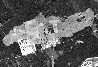
Čeština: Jáchymov, osada Vršek s uranovým dolem Barbora a pracovním táborem |
| Date | |
| Source | https://micka.cenia.cz/record/basic/50210752-9d9c-4f47-956b-1951c0a80137 |
| Author | Historická ortofotomapa © CENIA 2010 a © GEODIS Brno, spol. s r.o. 2010 Podkladové letecké snímky poskytl VGHMÚř Dobruška, © MO ČR 2009. |
| Camera location | | View this and other nearby images on: OpenStreetMap |
|---|
,_historick%C3%A1_ortofotomapa_(50._l%C3%A9ta).jpg¶ms=050.377919_N_0012.868748_E_globe:Earth_type:camera__&language=en-gb)
Licensing
This file is licensed under the Creative Commons Attribution 4.0 International licence.
- You are free:
- to share – to copy, distribute and transmit the work
- to remix – to adapt the work
- Under the following conditions:
- attribution – You must give appropriate credit, provide a link to the licence, and indicate if changes were made. You may do so in any reasonable manner, but not in any way that suggests the licensor endorses you or your use.
File history
Click on a date/time to view the file as it appeared at that time.
| Date/Time | Thumbnail | Dimensions | User | Comment | |
|---|---|---|---|---|---|
| current | 18:46, 16 February 2024 | | 3,116 × 2,145 (2.84 MB) | wikimediacommons>Hubert Kororo | Uploaded a work by Historická ortofotomapa © CENIA 2010 a © GEODIS Brno, spol. s r.o. 2010 Podkladové letecké snímky poskytl VGHMÚř Dobruška, © MO ČR 2009. from https://micka.cenia.cz/record/basic/50210752-9d9c-4f47-956b-1951c0a80137 with UploadWizard |
File usage
There are no pages that use this file.
,_historická_ortofotomapa_(50._léta).jpg)