Q629140: Difference between revisions
From Underfoot
Bot: Automated import of articles |
Bot: Automated import of articles *** existing text overwritten *** |
||
| Line 1: | Line 1: | ||
{{Page|Devils Hole|Sites|spring in Nye County, Nevada, | {{Page|Devils Hole|Sites|spring in Nye County, Nevada, United States|Ash Meadows Springs}} | ||
Latest revision as of 12:30, 1 September 2025
Devils Hole is a geologic formation located in a detached unit of Death Valley National Park and surrounded by the Ash Meadows National Wildlife Refuge, in Nye County, Nevada, in the Southwestern United States.
Wikimedia, Wikidata
Ash Meadows Springs
United States,

link={{{3}}}
Ash Meadows Springs
United States,

-
Location: 36.4254, -116.2914, KML, Cluster Map, Maps,
2 places
-

Devil's Hole Vent ⓘ
-

Devils Hole ⓘ
spring in Nye County, Nevada, United States
 Sketch showing underground features of Devils Hole Cave above and below water surface
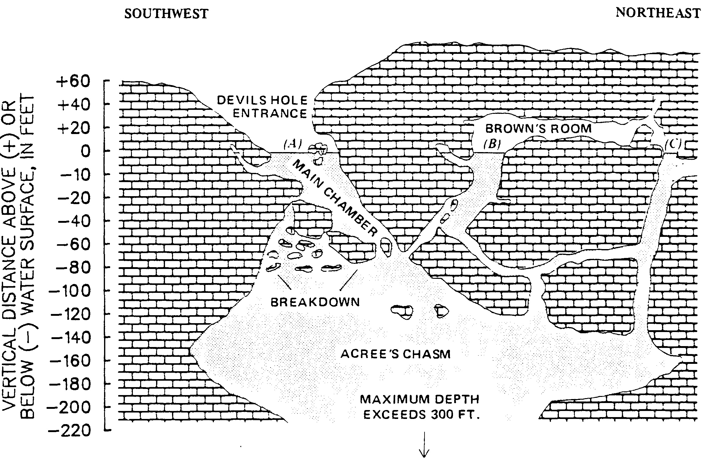 Sketch showing underground features of Devils Hole cavern system
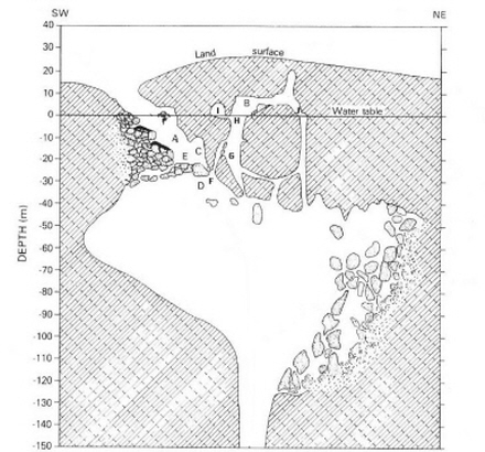 Diagram of Devils Cave
 Devils Hole 4
 Devils Hole 1
 Devils Hole 6
 Devils Hole 2
 Devils Hole 3
 Devils Hole 7
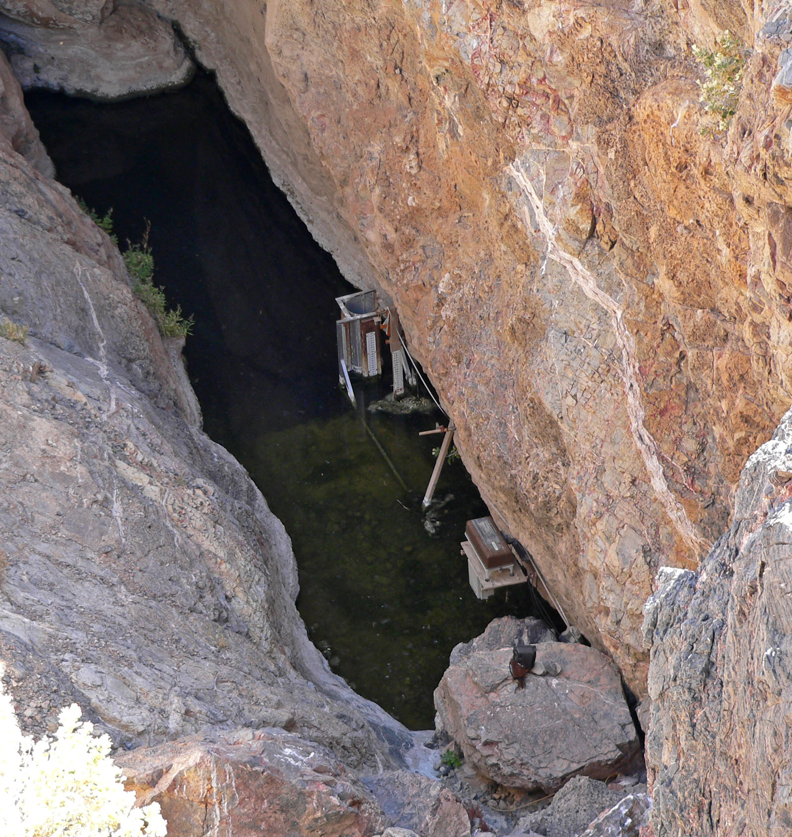 Devils Hole 5
- Devils Hole Calcite Was Precipitated at ±1°C Stable Aquifer Temperatures During the Last Half Million Years - scientific article, 2021
- Population Size of Devils Hole Pupfish (Cyprinodon diabolis) Correlates with Water Level - scientific article published in February 2001, Q1860
- Response: Dating of the Devils Hole Calcite - scientific article published on 01 March 1993, Q1860
- A response to "Milankovitch theory viewed from Devils Hole" by J. Imbrie, A.C. Mix and D.G. Martinson - scientific article published in 1993
- Delta13C and delta18O isotopic composition of CaCO3 measured by continuous flow isotope ratio mass spectrometry: statistical evaluation and verification by application to Devils Hole core DH-11 calcite - scientific article published in January 2002, Q1860
- Devils Hole paleotemperatures and implications for oxygen isotope equilibrium fractionation - , Q1860, 2014
- Testing an ecophysiological mechanism of morphological plasticity in pupfish and its relevance to conservation efforts for endangered Devils Hole pupfish - scientific article published on September 2006, Q1860
- Paleoclimatic Inferences from a 120,000-Yr Calcite Record of Water-Table Fluctuation in Browns Room of Devils Hole, Nevada - article by Barney J. Szabo et al published January 1994 in Quaternary Research, Q1860
- Digging the pupfish out of its hole: risk analyses to guide harvest of Devils Hole pupfish for captive breeding - scientific article published on September 9, 2014, Q1860, online
- A comparative study of prokaryotic diversity and physicochemical characteristics of Devils Hole and the Ash Meadows Fish Conservation Facility, a constructed analog - scientific article, Q1860, 2018
- Novel method for determining 234U–238U ages of Devils Hole 2 cave calcite - , 2020
- Paleoclimate. Ice ages, the California Current, and Devils Hole - scientific article published on 7 June 2001, Q1860
- Condensation-corrosion speleogenesis above a carbonate-saturated aquifer: Devils Hole Ridge, Nevada - scholarly article, Q1860, 2015
- Phylogenetics support an ancient common origin of two scientific icons: Devils Hole and Devils Hole pupfish - scientific article, Q1860, 2016
- When pupfish got to Devils Hole - journal article; published in Nature on 2016-06-29, Q1860
- When pupfish got to Devils Hole - journal article; published in Nature on 2016-06-29, Q1860
- Identifying Sources of Error in Surveys of Devils Hole Pupfish (Cyprinodon diabolis) - scientific article published in March 2012, Q1860
- Mass-Spectrometric 230Th-234U-238U Dating of the Devils Hole Calcite Vein - scientific article published in October 1992, Q1860
- Tectonic Speleogenesis of Devils Hole, Nevada, and Implications for Hydrogeology and the Development of Long, Continuous Paleoenvironmental Records - article, Q1860, 1994
- Radiation windows as indicators of an astronomical influence on the Devil's Hole chronology - scholarly article, Q1860, 1996
- Data from Devils Hole Core DH-11 - scientific article published in 1997
- Twenty Years of Marine Carbon Cycle Observations at Devils Hole Bermuda Provide Insights into Seasonal Hypoxia, Coral Reef Calcification, and Ocean Acidification - , 2017
- Calibration of the calcite–water oxygen-isotope geothermometer at Devils Hole, Nevada, a natural laboratory - scholarly article, Q1860, 2007
- 500,000-year stable carbon isotopic record from devils hole, nevada - scientific article published in January 1994, Q1860
- In-situ growth of calcite at Devils Hole, Nevada: Comparison of field and laboratory rates to a 500,000 year record of near-equilibrium calcite growth - article published in 2000
- Response to Comments on "Reconciliation of the Devils Hole climate record with orbital forcing". - scientific article, Q1860, 2016
- Milankovitch theory viewed from Devils Hole - scientific article published in Nature, Q1860, 1993
- Comment on "Reconciliation of the Devils Hole climate record with orbital forcing" - scientific article published in Science, Q1860, 2016
- An investigation of regional tectonic strain on water levels in Devils Hole, Death Valley National Park, Nevada - scholarly article, 2007
- Egg viability and ecology of Devils Hole pupfish: Insights from captive propagation - scientific article published in 1995, Q1860
- Potential reconciliation of Devils Hole and deep-sea pleistocene chronologies - , 1994
- Dating of the devils hole calcite vein - scientific article published in March 1993, Q1860
- Dating the Vostok ice core record by importing the Devils Hole chronology - scientific article published in December 2001
- Comment on "Reconciliation of the Devils Hole climate record with orbital forcing" - scientific article published on 01 October 2016, Q1860
- Heat flow and 2D multichannel seismic reflection survey of the Devil's Hole geothermal reservoir in the Wagner basin, northern Gulf of California - scholarly article, Q1860, 2022
- Novel method for determining 234U–238U ages of Devils Hole 2 cave calcite (Nevada) - scientific article, 2021
- Last interglacial in Devils Hole - scientific article published in Nature, Q1860, 1993
- The California Current, Devils Hole, and Pleistocene climate - scientific article, Q1860, 2002
- Best available science still supports an ancient common origin of Devils Hole and Devils Hole pupfish - scientific article published on 14 February 2018
- The chronology for the δ18O record from Devils Hole, Nevada, extended into the Mid-Holocene - scientific article published in 2011, online
- Devils Hole, Nevada–A Primer - scholarly article, 2012
- Last interglacial in Devils Hole - , Q1860, 1993
- Groundwater characterization and effects of pumping in the Death Valley regional groundwater flow system, Nevada and California, with special reference to Devils Hole - scholarly article, Q1860, 2020
- Reconciliation of the Devils Hole climate record with orbital forcing - scientific article, Q1860, 2016
- Devils Hole, Nevada, δ18O record extended to the mid-Holocene - scholarly article, 2006
- Interpreting seasonal convective mixing in Devils Hole, Death Valley National Park, from temperature profiles observed by fiber-optic distributed temperature sensing - scientific article published in May 2012
- Continuous 500,000-year climate record from vein calcite in devils hole, nevada - scientific article published in October 1992, Q1860, online
- Geology of the Devils Hole area, Nevada - scholarly article, 1988
| Type | Subtype | Date | Description | Notes | Source |
|---|---|---|---|---|---|
| site | cave | Devil's Hole Vent | cave, lake | Wikidata | |
| site | cave | Devils Hole | spring, cave, lake | Wikidata | |
| commons | image | Sketch showing underground features of Devils Hole Cave above and below water surface | Commons | ||
| commons | image | Sketch showing underground features of Devils Hole cavern system | Commons | ||
| commons | image | Diagram of Devils Cave | Commons | ||
| commons | image | Devils Hole 4 | Commons | ||
| commons | image | Devils Hole 1 | Commons | ||
| commons | image | Devils Hole 6 | Commons | ||
| commons | image | Devils Hole 2 | Commons | ||
| commons | image | Devils Hole 3 | Commons | ||
| commons | image | Devils Hole 7 | Commons | ||
| commons | image | Devils Hole 5 | Commons | ||