Loading map...
{"minzoom":false,"maxzoom":false,"mappingservice":"leaflet","width":"auto","height":"600px","centre":false,"title":"","label":"","icon":"","lines":[],"polygons":[],"circles":[],"rectangles":[],"copycoords":false,"static":false,"zoom":false,"defzoom":14,"layers":["OpenStreetMap","Esri.WorldImagery"],"image layers":[],"overlays":[],"resizable":false,"fullscreen":true,"scrollwheelzoom":true,"cluster":false,"clustermaxzoom":20,"clusterzoomonclick":true,"clustermaxradius":1,"clusterspiderfy":true,"geojson":"","clicktarget":"","imageLayers":[],"locations":[{"text":"\u003Cb\u003E\u003Cdiv class=\"mw-parser-output\"\u003E\u003Cp\u003ECornish Hush Mine\u003C/b\u003E\u003Cdiv class=\"mw-parser-output\"\u003E\u003Cp\u003Emine in Wear Valley, United Kingdom\n\u003C/p\u003E\u003C/div\u003E","title":"Cornish Hush Mine@mine in Wear Valley, United Kingdom\n","link":"","lat":54.699,"lon":-1.996,"icon":"/images/d/d2/Red-marker.png"},{"text":"\u003Cb\u003E\u003Cdiv class=\"mw-parser-output\"\u003E\u003Cp\u003E\u003Ca href=\"/Q124858416\" title=\"Q124858416\"\u003EDurham Royal Observer Corps Group Headquarters\u003C/a\u003E\u003C/b\u003E\u003Cdiv class=\"mw-parser-output\"\u003E\u003Cp\u003ERoyal Observer Corps Group Headquarters, bunker\n\u003C/p\u003E\u003C/div\u003E","title":"Durham Royal Observer Corps Group Headquarters@ Royal Observer Corps Group Headquarters, bunker\n","link":"","lat":54.7807,"lon":-1.57464,"icon":"/images/6/6e/M_bunker.png"},{"text":"\u003Cb\u003E\u003Cdiv class=\"mw-parser-output\"\u003E\u003Cp\u003E\u003Ca href=\"/Q124837461\" title=\"Q124837461\"\u003EHexham Cold Store\u003C/a\u003E\u003C/b\u003E\u003Cdiv class=\"mw-parser-output\"\u003E\u003Cp\u003Ewarehouse, bunker\n\u003C/p\u003E\u003C/div\u003E","title":"Hexham Cold Store@ warehouse, bunker\n","link":"","lat":54.9743,"lon":-2.09825,"icon":"/images/6/6e/M_bunker.png"},{"text":"\u003Cb\u003E\u003Cdiv class=\"mw-parser-output\"\u003E\u003Cp\u003E\u003Ca href=\"/Q5267156\" title=\"Q5267156\"\u003EDevil's Grinding Mill\u003C/a\u003E\u003C/b\u003E\u003Cdiv class=\"mw-parser-output\"\u003E\u003Cp\u003Ecave\n\u003C/p\u003E\u003C/div\u003E","title":"Devil's Grinding Mill@ cave\n","link":"","lat":54.4623,"lon":-2.35162,"icon":"/images/4/48/M_cave.png"},{"text":"\u003Cb\u003E\u003Cdiv class=\"mw-parser-output\"\u003E\u003Cp\u003E\u003Ca href=\"/Q17536896\" title=\"Q17536896\"\u003EGrotto And Icehouse\u003C/a\u003E\u003C/b\u003E\u003Cdiv class=\"mw-parser-output\"\u003E\u003Cp\u003Egrotto\n\u003C/p\u003E\u003C/div\u003E","title":"Grotto And Icehouse@ grotto\n","link":"","lat":54.5045,"lon":-1.73919,"icon":"/images/4/48/M_cave.png"},{"text":"\u003Cb\u003E\u003Cdiv class=\"mw-parser-output\"\u003E\u003Cp\u003E\u003Ca href=\"/Q26424979\" title=\"Q26424979\"\u003EGrotto Approximately 8 Metres To South West Of Bear Park\u003C/a\u003E\u003C/b\u003E\u003Cdiv class=\"mw-parser-output\"\u003E\u003Cp\u003Egrotto\n\u003C/p\u003E\u003C/div\u003E","title":"Grotto Approximately 8 Metres To South West Of Bear Park@ grotto\n","link":"","lat":54.2956,"lon":-1.99225,"icon":"/images/4/48/M_cave.png"},{"text":"\u003Cb\u003E\u003Cdiv class=\"mw-parser-output\"\u003E\u003Cp\u003E\u003Ca href=\"/Q26294870\" title=\"Q26294870\"\u003EBeaumont Mine\u003C/a\u003E\u003C/b\u003E\u003Cdiv class=\"mw-parser-output\"\u003E\u003Cp\u003Emine\n\u003C/p\u003E\u003C/div\u003E","title":"Beaumont Mine@ mine\n","link":"","lat":54.8044,"lon":-2.2193,"icon":"/images/a/ab/M_mine.png"},{"text":"\u003Cb\u003E\u003Cdiv class=\"mw-parser-output\"\u003E\u003Cp\u003E\u003Ca href=\"/Q17658330\" title=\"Q17658330\"\u003EBeldi Hill Low Level lead mine and ore works\u003C/a\u003E\u003C/b\u003E\u003Cdiv class=\"mw-parser-output\"\u003E\u003Cp\u003Emine\n\u003C/p\u003E\u003C/div\u003E","title":"Beldi Hill Low Level lead mine and ore works@ mine\n","link":"","lat":54.402,"lon":-2.15073,"icon":"/images/a/ab/M_mine.png"},{"text":"\u003Cb\u003E\u003Cdiv class=\"mw-parser-output\"\u003E\u003Cp\u003E\u003Ca href=\"/Q17664419\" title=\"Q17664419\"\u003EBeldon lead mine and ore works at Beldon Shields\u003C/a\u003E\u003C/b\u003E\u003Cdiv class=\"mw-parser-output\"\u003E\u003Cp\u003Emine\n\u003C/p\u003E\u003C/div\u003E","title":"Beldon lead mine and ore works at Beldon Shields@ mine\n","link":"","lat":54.8408,"lon":-2.11232,"icon":"/images/a/ab/M_mine.png"},{"text":"\u003Cb\u003E\u003Cdiv class=\"mw-parser-output\"\u003E\u003Cp\u003E\u003Ca href=\"/Q17678372\" title=\"Q17678372\"\u003EBolton Parks Lead Mine and ore works\u003C/a\u003E\u003C/b\u003E\u003Cdiv class=\"mw-parser-output\"\u003E\u003Cp\u003Emine\n\u003C/p\u003E\u003C/div\u003E","title":"Bolton Parks Lead Mine and ore works@ mine\n","link":"","lat":54.3326,"lon":-1.95617,"icon":"/images/a/ab/M_mine.png"},{"text":"\u003Cb\u003E\u003Cdiv class=\"mw-parser-output\"\u003E\u003Cp\u003E\u003Ca href=\"/Q29904475\" title=\"Q29904475\"\u003EBrownley Hill mine\u003C/a\u003E\u003C/b\u003E\u003Cdiv class=\"mw-parser-output\"\u003E\u003Cp\u003Emine\n\u003C/p\u003E\u003C/div\u003E","title":"Brownley Hill mine@ mine\n","link":"","lat":54.7966,"lon":-2.34815,"icon":"/images/a/ab/M_mine.png"},{"text":"\u003Cb\u003E\u003Cdiv class=\"mw-parser-output\"\u003E\u003Cp\u003E\u003Ca href=\"/Q17674781\" title=\"Q17674781\"\u003ECarrshield lead mines and ore works\u003C/a\u003E\u003C/b\u003E\u003Cdiv class=\"mw-parser-output\"\u003E\u003Cp\u003Emine\n\u003C/p\u003E\u003C/div\u003E","title":"Carrshield lead mines and ore works@ mine\n","link":"","lat":54.8171,"lon":-2.30736,"icon":"/images/a/ab/M_mine.png"},{"text":"\u003Cb\u003E\u003Cdiv class=\"mw-parser-output\"\u003E\u003Cp\u003E\u003Ca href=\"/Q5104890\" title=\"Q5104890\"\u003EChopwell Colliery\u003C/a\u003E\u003C/b\u003E\u003Cdiv class=\"mw-parser-output\"\u003E\u003Cp\u003Ecoal mine\n\u003C/p\u003E\u003C/div\u003E","title":"Chopwell Colliery@ coal mine\n","link":"","lat":54.9209,"lon":-1.82293,"icon":"/images/a/ab/M_mine.png"},{"text":"\u003Cb\u003E\u003Cdiv class=\"mw-parser-output\"\u003E\u003Cp\u003E\u003Ca href=\"/Q5135213\" title=\"Q5135213\"\u003EClose House Mine\u003C/a\u003E\u003C/b\u003E\u003Cdiv class=\"mw-parser-output\"\u003E\u003Cp\u003Emine\n\u003C/p\u003E\u003C/div\u003E","title":"Close House Mine@ mine\n","link":"","lat":54.6007,"lon":-2.23454,"icon":"/images/a/ab/M_mine.png"},{"text":"\u003Cb\u003E\u003Cdiv class=\"mw-parser-output\"\u003E\u003Cp\u003E\u003Ca href=\"/Q17674996\" title=\"Q17674996\"\u003EColdberry lead mine and associated hushes\u003C/a\u003E\u003C/b\u003E\u003Cdiv class=\"mw-parser-output\"\u003E\u003Cp\u003Emine\n\u003C/p\u003E\u003C/div\u003E","title":"Coldberry lead mine and associated hushes@ mine\n","link":"","lat":54.6561,"lon":-2.1036,"icon":"/images/a/ab/M_mine.png"},{"text":"\u003Cb\u003E\u003Cdiv class=\"mw-parser-output\"\u003E\u003Cp\u003E\u003Ca class=\"mw-selflink selflink\"\u003ECornish Hush Mine\u003C/a\u003E\u003C/b\u003E\u003Cdiv class=\"mw-parser-output\"\u003E\u003Cp\u003Emine\n\u003C/p\u003E\u003C/div\u003E","title":"Cornish Hush Mine@ mine\n","link":"","lat":54.6989,"lon":-1.99675,"icon":"/images/a/ab/M_mine.png"},{"text":"\u003Cb\u003E\u003Cdiv class=\"mw-parser-output\"\u003E\u003Cp\u003E\u003Ca href=\"/Q17662238\" title=\"Q17662238\"\u003EDerwentcote steel cementation furnace, iron finery forge and drift coal mine\u003C/a\u003E\u003C/b\u003E\u003Cdiv class=\"mw-parser-output\"\u003E\u003Cp\u003Emine\n\u003C/p\u003E\u003C/div\u003E","title":"Derwentcote steel cementation furnace, iron finery forge and drift coal mine@ mine\n","link":"","lat":54.9033,"lon":-1.79784,"icon":"/images/a/ab/M_mine.png"},{"text":"\u003Cb\u003E\u003Cdiv class=\"mw-parser-output\"\u003E\u003Cp\u003E\u003Ca href=\"/Q17674626\" title=\"Q17674626\"\u003EGreen Hurth lead mine and ore works\u003C/a\u003E\u003C/b\u003E\u003Cdiv class=\"mw-parser-output\"\u003E\u003Cp\u003Emine\n\u003C/p\u003E\u003C/div\u003E","title":"Green Hurth lead mine and ore works@ mine\n","link":"","lat":54.6893,"lon":-2.34268,"icon":"/images/a/ab/M_mine.png"},{"text":"\u003Cb\u003E\u003Cdiv class=\"mw-parser-output\"\u003E\u003Cp\u003E\u003Ca href=\"/Q17674548\" title=\"Q17674548\"\u003EGunnerside Gill lead mines and ore works\u003C/a\u003E\u003C/b\u003E\u003Cdiv class=\"mw-parser-output\"\u003E\u003Cp\u003Emine\n\u003C/p\u003E\u003C/div\u003E","title":"Gunnerside Gill lead mines and ore works@ mine\n","link":"","lat":54.4072,"lon":-2.09668,"icon":"/images/a/ab/M_mine.png"},{"text":"\u003Cb\u003E\u003Cdiv class=\"mw-parser-output\"\u003E\u003Cp\u003E\u003Ca href=\"/Q17665160\" title=\"Q17665160\"\u003EHudgill lead mine bingsteads, 200m north east of Hudgill Farm\u003C/a\u003E\u003C/b\u003E\u003Cdiv class=\"mw-parser-output\"\u003E\u003Cp\u003Emine\n\u003C/p\u003E\u003C/div\u003E","title":"Hudgill lead mine bingsteads, 200m north east of Hudgill Farm@ mine\n","link":"","lat":54.8108,"lon":-2.38721,"icon":"/images/a/ab/M_mine.png"},{"text":"\u003Cb\u003E\u003Cdiv class=\"mw-parser-output\"\u003E\u003Cp\u003E\u003Ca href=\"/Q48799223\" title=\"Q48799223\"\u003EHylton Colliery\u003C/a\u003E\u003C/b\u003E\u003Cdiv class=\"mw-parser-output\"\u003E\u003Cp\u003Ecoal mine\n\u003C/p\u003E\u003C/div\u003E","title":"Hylton Colliery@ coal mine\n","link":"","lat":54.6667,"lon":-1.83312,"icon":"/images/a/ab/M_mine.png"},{"text":"\u003Cb\u003E\u003Cdiv class=\"mw-parser-output\"\u003E\u003Cp\u003E\u003Ca href=\"/Q7057516\" title=\"Q7057516\"\u003EKillhope Museum\u003C/a\u003E\u003C/b\u003E\u003Cdiv class=\"mw-parser-output\"\u003E\u003Cp\u003E1984 local authority museum, lead mine, mining museum, \u003Ca rel=\"nofollow\" class=\"external text\" href=\"https://www.tripadvisor.com/1829581\"\u003Etripadvisor\u003C/a\u003E\n\u003C/p\u003E\u003C/div\u003E","title":"Killhope Museum@1984 local authority museum, lead mine, mining museum, tripadvisor\n","link":"","lat":54.783,"lon":-2.2733,"icon":"/images/e/e2/Tm_mine.png"},{"text":"\u003Cb\u003E\u003Cdiv class=\"mw-parser-output\"\u003E\u003Cp\u003E\u003Ca href=\"/Q17674598\" title=\"Q17674598\"\u003ELady's Rake lead mine\u003C/a\u003E\u003C/b\u003E\u003Cdiv class=\"mw-parser-output\"\u003E\u003Cp\u003Emine\n\u003C/p\u003E\u003C/div\u003E","title":"Lady's Rake lead mine@ mine\n","link":"","lat":54.7034,"lon":-2.30241,"icon":"/images/a/ab/M_mine.png"},{"text":"\u003Cb\u003E\u003Cdiv class=\"mw-parser-output\"\u003E\u003Cp\u003E\u003Ca href=\"/Q17674863\" title=\"Q17674863\"\u003ELead mines and smeltmills at Moulds Side west of Langthwaite\u003C/a\u003E\u003C/b\u003E\u003Cdiv class=\"mw-parser-output\"\u003E\u003Cp\u003Emine\n\u003C/p\u003E\u003C/div\u003E","title":"Lead mines and smeltmills at Moulds Side west of Langthwaite@ mine\n","link":"","lat":54.4221,"lon":-2.02468,"icon":"/images/a/ab/M_mine.png"},{"text":"\u003Cb\u003E\u003Cdiv class=\"mw-parser-output\"\u003E\u003Cp\u003E\u003Ca href=\"/Q17674487\" title=\"Q17674487\"\u003EMiddlehope Shield and Low Slit lead mines and ore works\u003C/a\u003E\u003C/b\u003E\u003Cdiv class=\"mw-parser-output\"\u003E\u003Cp\u003Emine\n\u003C/p\u003E\u003C/div\u003E","title":"Middlehope Shield and Low Slit lead mines and ore works@ mine\n","link":"","lat":54.7496,"lon":-2.14871,"icon":"/images/a/ab/M_mine.png"},{"text":"\u003Cb\u003E\u003Cdiv class=\"mw-parser-output\"\u003E\u003Cp\u003E\u003Ca href=\"/Q17674526\" title=\"Q17674526\"\u003EMiddle Greenlaws Level lead mine and ore works\u003C/a\u003E\u003C/b\u003E\u003Cdiv class=\"mw-parser-output\"\u003E\u003Cp\u003Emine\n\u003C/p\u003E\u003C/div\u003E","title":"Middle Greenlaws Level lead mine and ore works@ mine\n","link":"","lat":54.7278,"lon":-2.17321,"icon":"/images/a/ab/M_mine.png"},{"text":"\u003Cb\u003E\u003Cdiv class=\"mw-parser-output\"\u003E\u003Cp\u003E\u003Ca href=\"/Q17674848\" title=\"Q17674848\"\u003EPark Level lead mine with ore works on Killhope Burn\u003C/a\u003E\u003C/b\u003E\u003Cdiv class=\"mw-parser-output\"\u003E\u003Cp\u003Emine\n\u003C/p\u003E\u003C/div\u003E","title":"Park Level lead mine with ore works on Killhope Burn@ mine\n","link":"","lat":54.7815,"lon":-2.27139,"icon":"/images/a/ab/M_mine.png"},{"text":"\u003Cb\u003E\u003Cdiv class=\"mw-parser-output\"\u003E\u003Cp\u003E\u003Ca href=\"/Q17674611\" title=\"Q17674611\"\u003EPike Law lead hushes and mines\u003C/a\u003E\u003C/b\u003E\u003Cdiv class=\"mw-parser-output\"\u003E\u003Cp\u003Emine\n\u003C/p\u003E\u003C/div\u003E","title":"Pike Law lead hushes and mines@ mine\n","link":"","lat":54.6781,"lon":-2.15097,"icon":"/images/a/ab/M_mine.png"},{"text":"\u003Cb\u003E\u003Cdiv class=\"mw-parser-output\"\u003E\u003Cp\u003E\u003Ca href=\"/Q20128010\" title=\"Q20128010\"\u003ERampgill mine\u003C/a\u003E\u003C/b\u003E\u003Cdiv class=\"mw-parser-output\"\u003E\u003Cp\u003Elead mine\n\u003C/p\u003E\u003C/div\u003E","title":"Rampgill mine@ lead mine\n","link":"","lat":54.7857,"lon":-2.33906,"icon":"/images/a/ab/M_mine.png"},{"text":"\u003Cb\u003E\u003Cdiv class=\"mw-parser-output\"\u003E\u003Cp\u003E\u003Ca href=\"/Q17663025\" title=\"Q17663025\"\u003EScordale lead mines\u003C/a\u003E\u003C/b\u003E\u003Cdiv class=\"mw-parser-output\"\u003E\u003Cp\u003Emine\n\u003C/p\u003E\u003C/div\u003E","title":"Scordale lead mines@ mine\n","link":"","lat":54.5965,"lon":-2.37389,"icon":"/images/a/ab/M_mine.png"},{"text":"\u003Cb\u003E\u003Cdiv class=\"mw-parser-output\"\u003E\u003Cp\u003E\u003Ca href=\"/Q80183623\" title=\"Q80183623\"\u003ETynebottom Mine\u003C/a\u003E\u003C/b\u003E\u003Cdiv class=\"mw-parser-output\"\u003E\u003Cp\u003Emine\n\u003C/p\u003E\u003C/div\u003E","title":"Tynebottom Mine@ mine\n","link":"","lat":54.7714,"lon":-2.40724,"icon":"/images/a/ab/M_mine.png"},{"text":"\u003Cb\u003E\u003Cdiv class=\"mw-parser-output\"\u003E\u003Cp\u003E\u003Ca href=\"/Q17658269\" title=\"Q17658269\"\u003EWest Stonesdale lead mine and ore works\u003C/a\u003E\u003C/b\u003E\u003Cdiv class=\"mw-parser-output\"\u003E\u003Cp\u003Emine\n\u003C/p\u003E\u003C/div\u003E","title":"West Stonesdale lead mine and ore works@ mine\n","link":"","lat":54.4279,"lon":-2.17712,"icon":"/images/a/ab/M_mine.png"},{"text":"\u003Cb\u003E\u003Cdiv class=\"mw-parser-output\"\u003E\u003Cp\u003E\u003Ca href=\"/Q17674573\" title=\"Q17674573\"\u003EWhitesike and Bentyfield lead mines and ore works\u003C/a\u003E\u003C/b\u003E\u003Cdiv class=\"mw-parser-output\"\u003E\u003Cp\u003Emine\n\u003C/p\u003E\u003C/div\u003E","title":"Whitesike and Bentyfield lead mines and ore works@ mine\n","link":"","lat":54.7766,"lon":-2.38633,"icon":"/images/a/ab/M_mine.png"},{"text":"\u003Cb\u003E\u003Cdiv class=\"mw-parser-output\"\u003E\u003Cp\u003E\u003Ca href=\"/Q17674540\" title=\"Q17674540\"\u003EWilliam Gill 19th century colliery on Stonesdale Moor\u003C/a\u003E\u003C/b\u003E\u003Cdiv class=\"mw-parser-output\"\u003E\u003Cp\u003Ecoal mine\n\u003C/p\u003E\u003C/div\u003E","title":"William Gill 19th century colliery on Stonesdale Moor@ coal mine\n","link":"","lat":54.4428,"lon":-2.13167,"icon":"/images/a/ab/M_mine.png"},{"text":"\u003Cb\u003E\u003Cdiv class=\"mw-parser-output\"\u003E\u003Cp\u003E\u003Ca href=\"/Q16903589\" title=\"Q16903589\"\u003EWitton Park Colliery\u003C/a\u003E\u003C/b\u003E\u003Cdiv class=\"mw-parser-output\"\u003E\u003Cp\u003Ecoal mine\n\u003C/p\u003E\u003C/div\u003E","title":"Witton Park Colliery@ coal mine\n","link":"","lat":54.6711,"lon":-1.73955,"icon":"/images/a/ab/M_mine.png"},{"text":"\u003Cb\u003E\u003Cdiv class=\"mw-parser-output\"\u003E\u003Cp\u003E\u003Ca href=\"/Q113015088\" title=\"Q113015088\"\u003EDurham Mining Museum\u003C/a\u003E\u003C/b\u003E\u003Cdiv class=\"mw-parser-output\"\u003E\u003Cp\u003Emining museum, \u003Ca rel=\"nofollow\" class=\"external text\" href=\"https://www.tripadvisor.com/12121057\"\u003Etripadvisor\u003C/a\u003E\n\u003C/p\u003E\u003C/div\u003E","title":"Durham Mining Museum@ mining museum, tripadvisor\n","link":"","lat":54.7,"lon":-1.58998,"icon":"/images/f/f6/Tm_museum.png"},{"text":"\u003Cb\u003E\u003Cdiv class=\"mw-parser-output\"\u003E\u003Cp\u003E\u003Ca href=\"/Q7057516\" title=\"Q7057516\"\u003EKillhope Museum\u003C/a\u003E\u003C/b\u003E\u003Cdiv class=\"mw-parser-output\"\u003E\u003Cp\u003E1984 local authority museum, lead mine, mining museum, \u003Ca rel=\"nofollow\" class=\"external text\" href=\"https://www.tripadvisor.com/1829581\"\u003Etripadvisor\u003C/a\u003E\n\u003C/p\u003E\u003C/div\u003E","title":"Killhope Museum@1984 local authority museum, lead mine, mining museum, tripadvisor\n","link":"","lat":54.7832,"lon":-2.2729,"icon":"/images/f/f6/Tm_museum.png"},{"text":"\u003Cb\u003E\u003Cdiv class=\"mw-parser-output\"\u003E\u003Cp\u003E\u003Ca href=\"/Q113370308\" title=\"Q113370308\"\u003EMining Art Museum\u003C/a\u003E\u003C/b\u003E\u003Cdiv class=\"mw-parser-output\"\u003E\u003Cp\u003E2017 art gallery, mining museum, \u003Ca rel=\"nofollow\" class=\"external text\" href=\"https://www.tripadvisor.com/12982479\"\u003Etripadvisor\u003C/a\u003E\n\u003C/p\u003E\u003C/div\u003E","title":"Mining Art Museum@2017 art gallery, mining museum, tripadvisor\n","link":"","lat":54.6657,"lon":-1.67282,"icon":"/images/f/f6/Tm_museum.png"},{"text":"\u003Cb\u003E\u003Cdiv class=\"mw-parser-output\"\u003E\u003Cp\u003E\u003Ca href=\"/Q124419264\" title=\"Q124419264\"\u003ENenthead Mines\u003C/a\u003E\u003C/b\u003E\u003Cdiv class=\"mw-parser-output\"\u003E\u003Cp\u003Emining museum, \u003Ca rel=\"nofollow\" class=\"external text\" href=\"https://www.tripadvisor.com/2093310\"\u003Etripadvisor\u003C/a\u003E\n\u003C/p\u003E\u003C/div\u003E","title":"Nenthead Mines@ mining museum, tripadvisor\n","link":"","lat":54.7844,"lon":-2.33682,"icon":"/images/f/f6/Tm_museum.png"},{"text":"\u003Cb\u003E\u003Cdiv class=\"mw-parser-output\"\u003E\u003Cp\u003E\u003Ca href=\"/Q116809181\" title=\"Q116809181\"\u003EFarnley Scar Tunnel\u003C/a\u003E\u003C/b\u003E\u003Cdiv class=\"mw-parser-output\"\u003E\u003Cp\u003Erailway tunnel\n\u003C/p\u003E\u003C/div\u003E","title":"Farnley Scar Tunnel@ railway tunnel\n","link":"","lat":54.9635,"lon":-2.00065,"icon":"/images/0/04/M_tunnel.png"},{"text":"\u003Cb\u003E\u003Cdiv class=\"mw-parser-output\"\u003E\u003Cp\u003E\u003Ca href=\"/Q116695223\" title=\"Q116695223\"\u003EHog Hill Tunnel\u003C/a\u003E\u003C/b\u003E\u003Cdiv class=\"mw-parser-output\"\u003E\u003Cp\u003Erailway tunnel\n\u003C/p\u003E\u003C/div\u003E","title":"Hog Hill Tunnel@ railway tunnel\n","link":"","lat":54.7589,"lon":-2.01305,"icon":"/images/0/04/M_tunnel.png"},{"text":"\u003Cb\u003E\u003Cdiv class=\"mw-parser-output\"\u003E\u003Cp\u003E\u003Ca href=\"/Q122178627\" title=\"Q122178627\"\u003EScotswood Tunnel\u003C/a\u003E\u003C/b\u003E\u003Cdiv class=\"mw-parser-output\"\u003E\u003Cp\u003Erailway tunnel\n\u003C/p\u003E\u003C/div\u003E","title":"Scotswood Tunnel@ railway tunnel\n","link":"","lat":54.9705,"lon":-1.69099,"icon":"/images/0/04/M_tunnel.png"},{"text":"\u003Cb\u003E\u003Cdiv class=\"mw-parser-output\"\u003E\u003Cp\u003E\u003Ca href=\"/Q116695293\" title=\"Q116695293\"\u003EShildon Tunnel\u003C/a\u003E\u003C/b\u003E\u003Cdiv class=\"mw-parser-output\"\u003E\u003Cp\u003Erailway tunnel\n\u003C/p\u003E\u003C/div\u003E","title":"Shildon Tunnel@ railway tunnel\n","link":"","lat":54.6359,"lon":-1.64542,"icon":"/images/0/04/M_tunnel.png"}],"imageoverlays":null}
.jpg)
 Buildings at Whitfield Brow (geograph 5197335)
 Derelict Mine Building (geograph 3612784)
 Iron box on moorland beside valley of Wager Burn (geograph 4722356)
 Mine site at Whitfield Brow (geograph 5914035)
 Narrow gauge mineral locomotive by Mr Stephen Lewin, Poole, Dorset, Engineer (The Engineer, 1 January 1875) (cropped) (cropped)
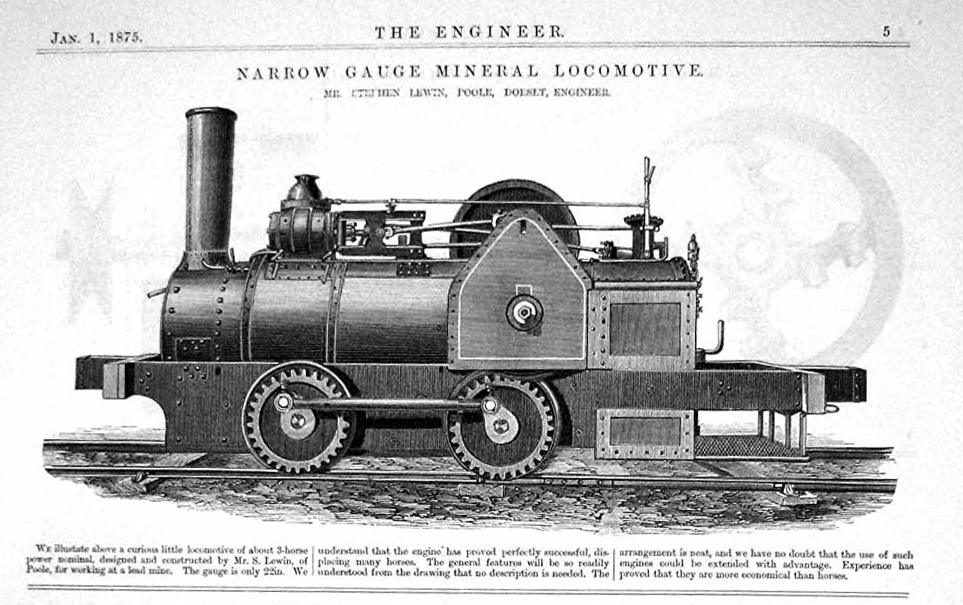 Narrow gauge mineral locomotive by Mr Stephen Lewin, Poole, Dorset, Engineer (The Engineer, 1 January 1875) (cropped)
 Narrow gauge mineral locomotive by Mr Stephen Lewin, Poole, Dorset, Engineer (The Engineer, 1 January 1875)
 Officials at Boltsburn Lead Mine. From left to right Prof Henry Louis, Mr Willis (Mine Manager), Capt Anthony Wilson (Weardale Lead Co Director)
 Old lead mine spoilheaps - geograph.org.uk - 1300836
 Spoil Heaps and Tractor with a Heavy Load (geograph 3612750)
.jpg)
.jpg)
.jpg)
.jpg)
%20(cropped)%20(cropped).jpg)
%20(cropped).jpg)
.jpg)
,%20Capt%20Anthony%20Wilson%20(Weardale%20Lead%20Co%20Director).png)
.jpg)