Shinkolobwe
From Underfoot
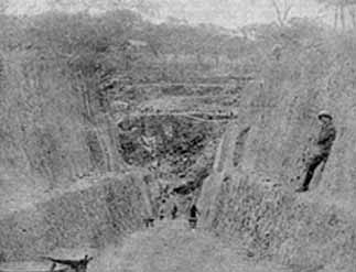
Shinkolobwe, or Kasolo, or Chinkolobew, or Shainkolobwe, was a radium and uranium mine in the Haut-Katanga Province of the Democratic Republic of the Congo (DRC), located 20 km (12.4 mi) west of Likasi, 20 km (12.4 mi) south of Kambove, and about 145 km (90.1 mi) northwest of Lubumbashi.
Wikimedia, Wikidata
Kasolo mine; Shinkolobwe; Shinkolobwe uranium mine
Democratic Republic of the Congo,
link={{{3}}}
Kasolo mine; Shinkolobwe; Shinkolobwe uranium mine
Democratic Republic of the Congo,

-
Location: -11.055, 26.5473, KML, Cluster Map, Maps,
1 places
-

Shinkolobwe ⓘ
name of a town and a mine in the Katanga province of the Democratic Republic of the Congo
 Curite-Soddyite-radmun-15a
 Schoepite-Curite-Uraninite-214948
 Kasolite-20884
 Schoepite-Curite-Uraninite-214949
 Becquerelite-Masuyite-Fourmarierite-180987
 Torbernite-220577
 Studtite-Uranophane-rads-34b
 Masuyit - Shinkolobwe
 Curit - Shinkolobwe
 Oursinite
| Type | Subtype | Date | Description | Notes | Source |
|---|---|---|---|---|---|
| site | mine | Shinkolobwe | uranium mine, Umicore, human settlement | Wikidata | |
| commons | image | Curite-Soddyite-radmun-15a | Commons | ||
| commons | image | Schoepite-Curite-Uraninite-214948 | Commons | ||
| commons | image | Kasolite-20884 | Commons | ||
| commons | image | Schoepite-Curite-Uraninite-214949 | Commons | ||
| commons | image | Becquerelite-Masuyite-Fourmarierite-180987 | Commons | ||
| commons | image | Torbernite-220577 | Commons | ||
| commons | image | Studtite-Uranophane-rads-34b | Commons | ||
| commons | image | Masuyit - Shinkolobwe | Commons | ||
| commons | image | Curit - Shinkolobwe | Commons | ||
| commons | image | Oursinite | Commons | ||