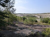
Granitsteinbruch W von Häuslberg
From Underfoot
Q59244642
Geotop in Landkreis Schwandorf in Bavaria, Germany
Website,
Wikidata
length: 100 metre,
Germany,
-
Location: 49.472, 12.255, KML, Cluster Map, Maps,
50 places
-

Beobachtungsbunker ⓘ
cultural heritage monument D-3-74-164-58 (0) in Waidhaus, Bavaria -
Cultural heritage D-3-6637-0008 in Ensdorf (Oberpfalz) ⓘ
cultural heritage monument in Ensdorf, Amberg-Sulzbach, Upper Palatinate, Bavaria, Germany -
Felsen Räuberhöhle NW von Linglmühle ⓘ
Geotop in Landkreis Neustadt a. d. Waldnaab, Lkr. (Stadt) in Bavaria, Germany -
Lourdesgrotte Dorfstraße 8 in Freihung ⓘ
cultural heritage monument D-3-71-121-12 (2) in Freihung, Bavaria -
Lourdesgrotte Ortsstraße 29: Nähe Ortsstraße: Ortsstraße 29: Ortsstraße 31a in Ebermannsdorf ⓘ
cultural heritage monument D-3-71-118-9 (2) in Ebermannsdorf, Bavaria -
Lourdesgrotte Weidenthal 26 in Guteneck ⓘ
cultural heritage monument D-3-76-133-13 (2) in Guteneck, Bavaria -
Aufgel. Steinbruch NE von Großschönbrunn ⓘ
Geotop in Landkreis Amberg-Sulzbach in Bavaria, Germany -
Braunkohletagebau südlich Wackersdorf ⓘ
-
Cornelia shaft, Hagendorf South open cut ⓘ
Hagendorf, Waidhaus -
Ehem. Glassandgrube N von Atzmannsricht ⓘ
Geotop in Landkreis Amberg-Sulzbach in Bavaria, Germany -
Ehem. Granitsteinbrüche SE von Gleiritsch ⓘ
Geotop in Landkreis Schwandorf in Bavaria, Germany -
Ehem. Steinbruch am Pfahl des Schwärzenbergs NW von Strahlfeld ⓘ
Geotop in Landkreis Cham in Bavaria, Germany -
Ehemalige Sandgrube E von Diebis ⓘ
Geotop in Landkreis Amberg-Sulzbach in Bavaria, Germany -
Ehemalige Steinbrüche NW von Ödmiesbach ⓘ
Geotop in Landkreis Schwandorf in Bavaria, Germany -
Ehemaliger Kalksteinbruch bei Rieden ⓘ
Geotop in Landkreis Amberg-Sulzbach in Bavaria, Germany -
Ehemaliger Quarzabbau W von Riedlhof ⓘ
Geotop in Landkreis Neustadt a. d. Waldnaab, Lkr. (Stadt) in Bavaria, Germany -
Ehemaliger Steinbruch am Pfahl südöstlich von Fronau ⓘ
Geotop in Landkreis Schwandorf in Bavaria, Germany -
Ehemaliger Steinbruch am Regen SW von Marienthal ⓘ
Geotop in Landkreis Schwandorf in Bavaria, Germany -
Ehemaliger Steinbruch am südöstlichen-Hang des Kulm ⓘ
Geotop in Landkreis Schwandorf in Bavaria, Germany -
Ehemaliger Steinbruch an der Luhe E von Michldorf ⓘ
Geotop in Landkreis Neustadt a. d. Waldnaab, Lkr. (Stadt) in Bavaria, Germany -
Ehemaliger Steinbruch bei Dietersdorf ⓘ
Geotop in Landkreis Schwandorf in Bavaria, Germany -
Ehemaliger Steinbruch bei Hammertiefenbach ⓘ
Geotop in Landkreis Cham in Bavaria, Germany -
Ehemaliger Steinbruch bei Oberschleif ⓘ
Geotop in Landkreis Neustadt a. d. Waldnaab, Lkr. (Stadt) in Bavaria, Germany -
Ehemaliger Steinbruch ESE von Schellhof ⓘ
Geotop in Landkreis Cham in Bavaria, Germany -
Ehemaliger Steinbruch im Pingartener Porphyr ⓘ
quarry in Germany -
Ehemaliger Steinbruch NW von Jeding ⓘ
Geotop in Landkreis Schwandorf in Bavaria, Germany -
Ehemaliger Steinbruch NW von Leuchtenberg ⓘ
Geotop in Landkreis Neustadt a. d. Waldnaab, Lkr. (Stadt) in Bavaria, Germany -
Ehemaliger Steinbruch östlich von Königsreuth ⓘ
Geotop in Landkreis Schwandorf in Bavaria, Germany -
Ehemaliger Steinbruch SE von Prackendorf ⓘ
Geotop in Landkreis Schwandorf in Bavaria, Germany -
Ehemaliger Steinbruch SW von Kadermühle ⓘ
Geotop in Landkreis Schwandorf in Bavaria, Germany -
Ehemaliger Steinbruch W von Leuchtenberg ⓘ
Geotop in Landkreis Neustadt a. d. Waldnaab, Lkr. (Stadt) in Bavaria, Germany -
Ehemaliger Steinbruch W von Waldau ⓘ
Geotop in Landkreis Neustadt a. d. Waldnaab, Lkr. (Stadt) in Bavaria, Germany -
Ehemaliger Steinbruch westlich von Stefling ⓘ
Geotop in Landkreis Schwandorf in Bavaria, Germany -

Ehemaliges Braunkohlengrubenfeld Rauberweiher ⓘ
Geotop in Landkreis Schwandorf in Bavaria, Germany -
Goldbergbauspuren im Murachtal unterhalb von Tannermühle ⓘ
Geotop in Landkreis Schwandorf in Bavaria, Germany -
Goldseifenwerk Alte Schanze bei Diepoltsried ⓘ
Geotop in Landkreis Cham in Bavaria, Germany -
Goldseifenwerk S von Gaisheim ⓘ
Geotop in Landkreis Neustadt a. d. Waldnaab, Lkr. (Stadt) in Bavaria, Germany -
Goldseifenwerke im Krammaholz ⓘ
Geotop in Landkreis Cham in Bavaria, Germany -
Granitsteinbruch W von Häuslberg ⓘ
Geotop in Landkreis Schwandorf in Bavaria, Germany -
Güttingloch und Goldbergbauspuren Gütting-Unterlangau ⓘ
Geotop in Landkreis Schwandorf in Bavaria, Germany -
Kalkbruch am Westfuß des Riedener Schloßberges ⓘ
Geotop in Landkreis Amberg-Sulzbach in Bavaria, Germany -

Mühlsteinbruch W von Massenricht ⓘ
Geotop in Landkreis Amberg-Sulzbach in Bavaria, Germany -
Quarzbruch am Hirschberg E von Hofenstetten ⓘ
Geotop in Landkreis Schwandorf in Bavaria, Germany -
Sandgrube N von Pirkerziegelhütte ⓘ
Geotop in Landkreis Neustadt a. d. Waldnaab, Lkr. (Stadt) in Bavaria, Germany -
Sandgrube NNW von Atzmannsricht ⓘ
Geotop in Landkreis Amberg-Sulzbach in Bavaria, Germany -

Steinbruch Blockhütte Weiden ⓘ
-
Steinbruch ENE von Löwenbrunn ⓘ
Geotop in Landkreis Cham in Bavaria, Germany -
Steinbruch Lindtach WNW von Strahlfeld ⓘ
Geotop in Landkreis Cham in Bavaria, Germany -
Steinbruch NNE von Theuern ⓘ
Geotop in Landkreis Amberg-Sulzbach in Bavaria, Germany -
Tongrube am Silberberg SW von Bruck i. d. Opf. ⓘ
Geotop in Landkreis Schwandorf in Bavaria, Germany