Notts Pot
From Underfoot
Q7063772
Notts Pot is cave system on Leck Fell, Lancashire, England. It is described as 'the most concentrated vertical maze in Britain'.
Wikimedia, Wikidata
United Kingdom,
- Council for the Northern Caving Community page@
- cavemaps.org page@
Location: 54.1949, -2.5056, KML, Cluster Map, Maps,
199 places
-

Alum Pot ⓘ
Open shaft pothole in North Yorkshire -

Aquamole Pot ⓘ
Cave in North Yorkshire, England -
Ayegill Caverns ⓘ
cave in Yorkshire, UK -

Bar Pot ⓘ
cave in the UK -
Barbon Pot ⓘ
cave in Yorkshire, UK -
Barghs Cave ⓘ
cave in Yorkshire, UK -
Batty Cave ⓘ
cave in Yorkshire, UK -
Beck Head Stream Cave ⓘ
cave in Yorkshire, UK -
Big Meanie ⓘ
cave in Yorkshire, UK -
Birks Fell Cave ⓘ
cave in Yorkshire, UK -
Birkwith Cave ⓘ
cave in Yorkshire, UK -
Black Reef Cave ⓘ
cave in Yorkshire, UK -
Black Shiver Pot ⓘ
cave in Yorkshire, UK -
Blake Bank Moss Cave ⓘ
cave in Yorkshire, UK -
Boggarts Roaring Holes ⓘ
cave in Yorkshire, UK -
Boundary Pot ⓘ
cave in Yorkshire, UK -
Bown Scar ⓘ
cave in Yorkshire, UK -
Boxhead Pot ⓘ
cave on Leck Fell, Lancashire, England -
Brackenbottom Pot ⓘ
cave in Yorkshire, UK -
Broken Finger Pot ⓘ
cave in Yorkshire, UK -
Brown Hill Pot ⓘ
cave in Yorkshire, UK -
Bye George ⓘ
cave in Yorkshire, UK -
Calf Holes ⓘ
cave in Yorkshire, UK -
Car Pot ⓘ
cave in Yorkshire, UK -
Casterton Pot ⓘ
cave in Yorkshire, UK -
Cherry Tree Hole ⓘ
cave in Yorkshire, UK -
Christmas Pot ⓘ
cave in Yorkshire, UK -
Clapham Beck Head ⓘ
cave in Yorkshire, UK -
Clapham Bottoms Pot ⓘ
cave in Yorkshire, UK -
Cliffe Force Cave ⓘ
cave in Yorkshire, UK -
Conduit Spring Cave ⓘ
cave in Yorkshire, UK -
Coppice Cave ⓘ
cave in Yorkshire, UK -
Corkys Pot ⓘ
cave in Yorkshire, UK -
County Pot ⓘ
cave in Yorkshire, UK -
Crescent Pot ⓘ
cave in Yorkshire, UK -
Daimler Hole ⓘ
cave in Yorkshire, UK -
Dale Barn Cave ⓘ
cave in Yorkshire, UK -
Dale Head Pot ⓘ
cave in Yorkshire, UK -
Dead Dobbin ⓘ
cave in Yorkshire, UK -

Death's Head Hole ⓘ
cave on Leck Fell, in Lancashire, England -
Deaths Head ⓘ
cave in Yorkshire, UK -
Diccan Pot ⓘ
cave in Yorkshire, UK -

Disappointment Pot ⓘ
cave in the UK -
Dismal Hill ⓘ
cave in Yorkshire, UK -
Dog Hole Cave ⓘ
Storth, Cumbria, England, also known as Fairy Cave -
Dog Holes Cave ⓘ
cave in Warton, Lancashire, England, UK -
Douk Gill Cave ⓘ
cave in Yorkshire, UK -
Dowkabottom Cave ⓘ
cave in Yorkshire, UK -
Dry Gill Cave ⓘ
cave in Yorkshire, UK -
Dub Cote Cave ⓘ
cave in Yorkshire, UK -

Easegill System ⓘ
cave system in Britain -
Echo Pot ⓘ
cave in Yorkshire, UK -
Eden Sike Cave ⓘ
cave in the UK -
Exhumation Hole ⓘ
cave in Yorkshire, UK -

Flood Entrance Pot ⓘ
cave in the UK -
Floyds Entrance ⓘ
cave in Yorkshire, UK -
Fossdale Beck Cave ⓘ
cave in Yorkshire, UK -
Fox Holes ⓘ
cave in Yorkshire, UK -

Gaping Gill ⓘ
cave in North Yorkshire -
Gatekirk Cave ⓘ
cave in Yorkshire, UK -
Gaze Gill Cave ⓘ
cave in Yorkshire, UK -
Giggel Rav Pot ⓘ
cave in Yorkshire, UK -
Gingling Hole ⓘ
cave in Yorkshire, UK -
Gods Bridge ⓘ
cave in Yorkshire, UK -
Grange Rigg Pot ⓘ
cave in Yorkshire, UK -

Great Douk Cave ⓘ
Cave in North Yorkshire, England -
Greensett Cave ⓘ
cave in Yorkshire, UK -
Grey Wife Hole ⓘ
cave in Yorkshire, UK -
Growling Hole ⓘ
cave in Yorkshire, UK -
Hagg Gill Pot ⓘ
cave in Yorkshire, UK -
Hallam Moss Cave ⓘ
cave in Yorkshire, UK -
Hammer Pot ⓘ
cave in Yorkshire, UK -
Hangmans Hole ⓘ
cave in Yorkshire, UK -
Hardrawkin Pot ⓘ
cave in Yorkshire, UK -
Henslers Pot ⓘ
cave in Yorkshire, UK -
High Hull Pot ⓘ
cave in Yorkshire, UK -
Hull Pot ⓘ
cave in Yorkshire, UK -
Hunt Pot ⓘ
cave in Yorkshire, UK -
Hurnel Moss Pot ⓘ
cave in Yorkshire, UK -
Hurtle Pot ⓘ
cave in Yorkshire, UK -
Illusion ⓘ
cave in Yorkshire, UK -

Ingleborough Cave ⓘ
cave in United Kingdom -
Ireby Fell Cavern ⓘ
Cave in Lancashire, England -
Jackdaw Hole ⓘ
cave in Yorkshire, UK -

Jib Tunnel ⓘ
cave in the UK -
Jib Tunnel (Dihedral) ⓘ
cave in Yorkshire, UK -
Jingle Pot ⓘ
cave in Yorkshire, UK -
Jockey Hole ⓘ
cave in Yorkshire, UK -
Joint Hole ⓘ
cave in Yorkshire, UK -
Jubilee Cave, Langcliffe Scar ⓘ
cave in Langcliffe, North Yorkshire, England, UK -
Juniper Gulf ⓘ
cave in the UK -
Katnot Cave ⓘ
cave in Yorkshire, UK -
Keld Head ⓘ
cave in Yorkshire, UK -
King Pot ⓘ
cave in Yorkshire, UK -
Kirkhead Cave ⓘ
cave in Lower Allithwaite, Cumbria, England, UK -
Knacker Trapper Hole ⓘ
cave in Yorkshire, UK -

Langcliffe Pot ⓘ
cave system in North Yorkshire -
Langstroth Cave ⓘ
cave in Yorkshire, UK -
Langstroth Pot ⓘ
cave in Yorkshire, UK -
Large Pot ⓘ
cave in Yorkshire, UK -
Ling Gill 7 ⓘ
cave in Yorkshire, UK -
Link Pot ⓘ
cave in Yorkshire, UK -
Little Pot ⓘ
cave in Yorkshire, UK -
Lizard Pot ⓘ
cave in Yorkshire, UK -

Long Churn Cave ⓘ
Cave in North Yorkshire, England -
Long Drop Cave ⓘ
cave in northern England -
Long Kin East Cave ⓘ
cave in Yorkshire, UK -
Long Kin East Pot ⓘ
cave in Yorkshire, UK -
Long Kin West ⓘ
cave in Yorkshire, UK -

Lost John's Cave ⓘ
cave in United Kingdom -
Lost Johns ⓘ
cave in Yorkshire, UK -
Lost Pot ⓘ
Cave in Lancashire, England -
Low Douk Cave ⓘ
cave in Yorkshire, UK -
Lower Sunset ⓘ
cave in Yorkshire, UK -
Magnetometer Pot ⓘ
cave in Yorkshire, UK -
Malham Cove Rising ⓘ
cave in Yorkshire, UK -
Marble Pot ⓘ
cave in Yorkshire, UK -
Marble Sink ⓘ
cave in Yorkshire, UK -
Marble Steps Pot ⓘ
cave in Yorkshire, UK -
Marilyn ⓘ
cave in Yorkshire, UK -
Meregill Hole ⓘ
cave in Yorkshire, UK -
Middle Scar Cave ⓘ
cave in Yorkshire, UK -
Midge Hole ⓘ
cave in Yorkshire, UK -
Mistral Hole ⓘ
cave in Yorkshire, UK -
Newby Moss Pot ⓘ
cave in Yorkshire, UK -
Nick Pot ⓘ
cave in Yorkshire, UK -
Nippikin Pot ⓘ
cave in Yorkshire, UK -
Notts Pot ⓘ
Cave in Lancashire, England -
November Hole ⓘ
cave in Yorkshire, UK -
Old Ing ⓘ
cave in Yorkshire, UK -
Out Sleets Beck Pot ⓘ
cave in Yorkshire, UK -
P101b ⓘ
cave in Yorkshire, UK -
Pasture Gill Pot ⓘ
cave in Yorkshire, UK -
Pay Sank ⓘ
cave in Yorkshire, UK -
Pegleg Pot ⓘ
cave in Yorkshire, UK -
Penyghent Long Churn ⓘ
cave in Yorkshire, UK -
Penyghent Pot ⓘ
cave in Yorkshire, UK -
Peterson Pot ⓘ
cave in Yorkshire, UK -
Pikedaw Calamine Caverns ⓘ
cave in Yorkshire, UK -
Pippikin Pot ⓘ
cave in Yorkshire, UK -
Pool Sink ⓘ
cave in Yorkshire, UK -
Quaking Pot ⓘ
cave in Yorkshire, UK -
Rat Hole, Gaping Gill ⓘ
cave entrance in North Yorkshire, England -
Rift Pot (Allotment) ⓘ
cave in Yorkshire, UK -
Ringle Mill Cave ⓘ
cave in Yorkshire, UK -
Roaring Hole ⓘ
cave in Yorkshire, UK -
Roger Kirk West Sink ⓘ
cave in Yorkshire, UK -
Rowantree Cave ⓘ
cave in Yorkshire, UK -

Rowten Pot ⓘ
cave in the parish of Thorton-in-Craven, North Yorkshire, UK -
Rumbling Hole ⓘ
cave in Lancashire, England -
Scoska Cave ⓘ
cave in Yorkshire, UK -
Short Drop Cave - Gavel Pot System ⓘ
cave in the UK -
Short Gill Cave ⓘ
cave in Yorkshire, UK -

Simpson Pot ⓘ
cave in North Yorkshire, England -

Skirwith Cave ⓘ
Cave in North Yorkshire, England -
Slanting Cave ⓘ
cave in Yorkshire, UK -
Sleets Gill Cave ⓘ
cave in Yorkshire, UK -
Slit Sinks ⓘ
cave in Yorkshire, UK -
Small Mammal Pot ⓘ
cave in Yorkshire, UK -
Snatcher Pot ⓘ
cave in Yorkshire, UK -
Southerscales Pot ⓘ
cave in Yorkshire, UK -
Spectacle Pot ⓘ
cave in Yorkshire, UK -
Spittle Croft Cave ⓘ
cave in Yorkshire, UK -
Strangle Pot ⓘ
cave in Yorkshire, UK -
Strans Gill Pot ⓘ
cave in Yorkshire, UK -
Stream Passage Pot ⓘ
cave in the UK -
Swan Dike Pot ⓘ
cave in Yorkshire, UK -
Sweetwater Hole ⓘ
cave in Yorkshire, UK -
Swindon Hole ⓘ
cave in Yorkshire, UK -
Swinsto Cave ⓘ
cave in North Yorkshire, England -
Swinsto Hole ⓘ
cave in Yorkshire, UK -
Swinsto South ⓘ
cave in Yorkshire, UK -
Tatham Wife Hole ⓘ
cave in Yorkshire, UK -
The Borehole ⓘ
cave in Yorkshire, UK -
The Mohole ⓘ
cave in Yorkshire, UK -
Three Counties System ⓘ
Cave system in England -
Top Sink ⓘ
cave in Yorkshire, UK -
Trapdoor Pot ⓘ
cave in Yorkshire, UK -
Turbary Pot ⓘ
cave in Yorkshire, UK -
Vesper Pot ⓘ
cave in Yorkshire, UK -

Victoria Cave, Langcliffe Scar ⓘ
cave in Langcliffe, North Yorkshire, England, UK -
Wades Entrance ⓘ
cave in Yorkshire, UK -
Washfold Pot ⓘ
cave in Yorkshire, UK -

Weathercote Cave ⓘ
Cave in North Yorkshire, England -
White Scar Caves ⓘ
cave in United Kingdom -
Winshaw Gill Pot ⓘ
cave in Yorkshire, UK -
Wretched Rabbit ⓘ
cave in Yorkshire, UK -
Yockenthwaite Pot ⓘ
cave in Yorkshire, UK -

Yordas Cave ⓘ
Cave in North Yorkshire, England -
Ashnott lead mine and lime kiln, 90m south of Ashnott ⓘ
lead mine in Newton, Lancashire, England, UK -
Clintsfield Colliery ⓘ
coal mine in Tatham, Lancashire, England, UK -
Dry Rigg Quarry ⓘ
gritstone quarry in North Yorkshire, England -
New Providence lead mine and ore works, 350m south of Moor End, north west of Kettlewell ⓘ
mine in Kettlewell with Starbotton, United Kingdom -
Nucleated coal mine and coke oven on Fountains Fell ⓘ
coal mine and coke oven in Halton Gill/Malham Moor, North Yorkshire, England, UK -
Trowbarrow Quarry ⓘ
quarry and nature reserve in Lancashire, England, UK -

Birkett Tunnel ⓘ
railway tunnel in the UK -

Blea Moor Tunnel ⓘ
railway tunnel in Cumbria and Yorkshire, England -

Hincaster Tunnel ⓘ
19th century canal tunnel -

Rise Hill Tunnel ⓘ
railway tunnel in the UK
 Notts2up
 Notts Pot entrance
 Stalagmite wall column in Notts 2 streamway
 Iron Kiln Hole (Notts Pot 2 ) Entrance
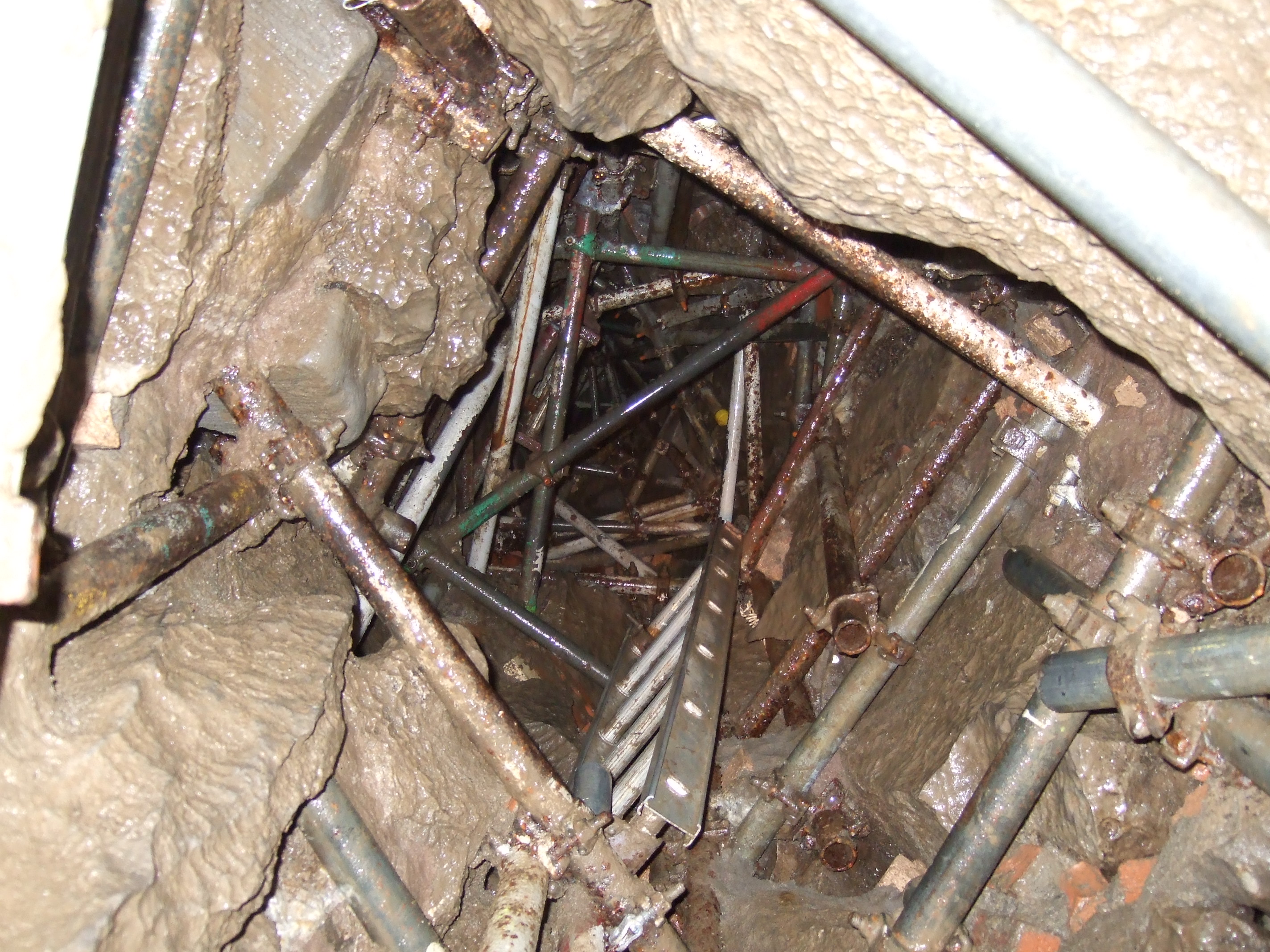
 Descending a shaft in Notts Pot
| Type | Subtype | Date | Description | Notes | Source |
|---|---|---|---|---|---|
| link | page | Council for the Northern Caving Community page@ | Wikidata | ||
| link | page | cavemaps.org page@ | Wikidata | ||
| site | cave | Alum Pot | cave | Wikidata | |
| site | cave | Aquamole Pot | cave | Wikidata | |
| site | cave | Ayegill Caverns | cave | Wikidata | |
| site | cave | Bar Pot | cave | Wikidata | |
| site | cave | Barbon Pot | cave | Wikidata | |
| site | cave | Barghs Cave | cave | Wikidata | |
| site | cave | Batty Cave | cave | Wikidata | |
| site | cave | Beck Head Stream Cave | cave | Wikidata | |
| site | cave | Big Meanie | cave | Wikidata | |
| site | cave | Birks Fell Cave | cave | Wikidata | |
| site | cave | Birkwith Cave | cave | Wikidata | |
| site | cave | Black Reef Cave | cave | Wikidata | |
| site | cave | Black Shiver Pot | cave | Wikidata | |
| site | cave | Blake Bank Moss Cave | cave | Wikidata | |
| site | cave | Boggarts Roaring Holes | cave | Wikidata | |
| site | cave | Boundary Pot | cave | Wikidata | |
| site | cave | Bown Scar | cave | Wikidata | |
| site | cave | Boxhead Pot | cave | Wikidata | |
| site | cave | Brackenbottom Pot | cave | Wikidata | |
| site | cave | Broken Finger Pot | cave | Wikidata | |
| site | cave | Brown Hill Pot | cave | Wikidata | |
| site | cave | Bye George | cave | Wikidata | |
| site | cave | Calf Holes | cave | Wikidata | |
| site | cave | Car Pot | cave | Wikidata | |
| site | cave | Casterton Pot | cave | Wikidata | |
| site | cave | Cherry Tree Hole | cave | Wikidata | |
| site | cave | Christmas Pot | cave | Wikidata | |
| site | cave | Clapham Beck Head | cave | Wikidata | |
| site | cave | Clapham Bottoms Pot | cave | Wikidata | |
| site | cave | Cliffe Force Cave | cave | Wikidata | |
| site | cave | Conduit Spring Cave | cave | Wikidata | |
| site | cave | Coppice Cave | cave | Wikidata | |
| site | cave | Corkys Pot | cave | Wikidata | |
| site | cave | County Pot | cave | Wikidata | |
| site | cave | Crescent Pot | cave | Wikidata | |
| site | cave | Daimler Hole | cave | Wikidata | |
| site | cave | Dale Barn Cave | cave | Wikidata | |
| site | cave | Dale Head Pot | cave | Wikidata | |
| site | cave | Dead Dobbin | cave | Wikidata | |
| site | cave | Death's Head Hole | cave | Wikidata | |
| site | cave | Deaths Head | cave | Wikidata | |
| site | cave | Diccan Pot | cave | Wikidata | |
| site | cave | Disappointment Pot | cave | Wikidata | |
| site | cave | Dismal Hill | cave | Wikidata | |
| site | cave | Dog Hole Cave | archaeological site, cave | Wikidata | |
| site | cave | Dog Holes Cave | cave | Wikidata | |
| site | cave | Douk Gill Cave | cave | Wikidata | |
| site | cave | Dowkabottom Cave | cave | Wikidata | |
| site | cave | Dry Gill Cave | cave | Wikidata | |
| site | cave | Dub Cote Cave | cave | Wikidata | |
| site | cave | Easegill System | cave | Wikidata | |
| site | cave | Echo Pot | cave | Wikidata | |
| site | cave | Eden Sike Cave | cave | Wikidata | |
| site | cave | Exhumation Hole | cave | Wikidata | |
| site | cave | Flood Entrance Pot | cave | Wikidata | |
| site | cave | Floyds Entrance | cave | Wikidata | |
| site | cave | Fossdale Beck Cave | cave | Wikidata | |
| site | cave | Fox Holes | cave | Wikidata | |
| site | cave | Gaping Gill | cave, waterfall | Wikidata | |
| site | cave | Gatekirk Cave | cave | Wikidata | |
| site | cave | Gaze Gill Cave | cave | Wikidata | |
| site | cave | Giggel Rav Pot | cave | Wikidata | |
| site | cave | Gingling Hole | cave | Wikidata | |
| site | cave | Gods Bridge | cave | Wikidata | |
| site | cave | Grange Rigg Pot | cave | Wikidata | |
| site | cave | Great Douk Cave | cave | Wikidata | |
| site | cave | Greensett Cave | cave | Wikidata | |
| site | cave | Grey Wife Hole | cave | Wikidata | |
| site | cave | Growling Hole | cave | Wikidata | |
| site | cave | Hagg Gill Pot | cave | Wikidata | |
| site | cave | Hallam Moss Cave | cave | Wikidata | |
| site | cave | Hammer Pot | cave | Wikidata | |
| site | cave | Hangmans Hole | cave | Wikidata | |
| site | cave | Hardrawkin Pot | cave | Wikidata | |
| site | cave | Henslers Pot | cave | Wikidata | |
| site | cave | High Hull Pot | cave | Wikidata | |
| site | cave | Hull Pot | cave | Wikidata | |
| site | cave | Hunt Pot | cave | Wikidata | |
| site | cave | Hurnel Moss Pot | cave | Wikidata | |
| site | cave | Hurtle Pot | cave | Wikidata | |
| site | cave | Illusion | cave | Wikidata | |
| site | cave | Ingleborough Cave | show cave | Wikidata | |
| site | cave | Ireby Fell Cavern | cave | Wikidata | |
| site | cave | Jackdaw Hole | cave | Wikidata | |
| site | cave | Jib Tunnel | cave | Wikidata | |
| site | cave | Jib Tunnel (Dihedral) | cave | Wikidata | |
| site | cave | Jingle Pot | cave | Wikidata | |
| site | cave | Jockey Hole | cave | Wikidata | |
| site | cave | Joint Hole | cave | Wikidata | |
| site | cave | Jubilee Cave, Langcliffe Scar | cave | Wikidata | |
| site | cave | Juniper Gulf | cave | Wikidata | |
| site | cave | Katnot Cave | cave | Wikidata | |
| site | cave | Keld Head | cave | Wikidata | |
| site | cave | King Pot | cave | Wikidata | |
| site | cave | Kirkhead Cave | cave | Wikidata | |
| site | cave | Knacker Trapper Hole | cave | Wikidata | |
| site | cave | Langcliffe Pot | cave | Wikidata | |
| site | cave | Langstroth Cave | cave | Wikidata | |
| site | cave | Langstroth Pot | cave | Wikidata | |
| site | cave | Large Pot | cave | Wikidata | |
| site | cave | Ling Gill 7 | cave | Wikidata | |
| site | cave | Link Pot | cave | Wikidata | |
| site | cave | Little Pot | cave | Wikidata | |
| site | cave | Lizard Pot | cave | Wikidata | |
| site | cave | Long Churn Cave | cave | Wikidata | |
| site | cave | Long Drop Cave | cave | Wikidata | |
| site | cave | Long Kin East Cave | cave | Wikidata | |
| site | cave | Long Kin East Pot | cave | Wikidata | |
| site | cave | Long Kin West | cave | Wikidata | |
| site | cave | Lost John's Cave | cave | Wikidata | |
| site | cave | Lost Johns | cave | Wikidata | |
| site | cave | Lost Pot | cave | Wikidata | |
| site | cave | Low Douk Cave | cave | Wikidata | |
| site | cave | Lower Sunset | cave | Wikidata | |
| site | cave | Magnetometer Pot | cave | Wikidata | |
| site | cave | Malham Cove Rising | cave | Wikidata | |
| site | cave | Marble Pot | cave | Wikidata | |
| site | cave | Marble Sink | cave | Wikidata | |
| site | cave | Marble Steps Pot | cave | Wikidata | |
| site | cave | Marilyn | cave | Wikidata | |
| site | cave | Meregill Hole | cave | Wikidata | |
| site | cave | Middle Scar Cave | cave | Wikidata | |
| site | cave | Midge Hole | cave | Wikidata | |
| site | cave | Mistral Hole | cave | Wikidata | |
| site | cave | Newby Moss Pot | cave | Wikidata | |
| site | cave | Nick Pot | cave | Wikidata | |
| site | cave | Nippikin Pot | cave | Wikidata | |
| site | cave | Notts Pot | cave | Wikidata | |
| site | cave | November Hole | cave | Wikidata | |
| site | cave | Old Ing | cave | Wikidata | |
| site | cave | Out Sleets Beck Pot | cave | Wikidata | |
| site | cave | P101b | cave | Wikidata | |
| site | cave | Pasture Gill Pot | cave | Wikidata | |
| site | cave | Pay Sank | cave | Wikidata | |
| site | cave | Pegleg Pot | cave | Wikidata | |
| site | cave | Penyghent Long Churn | cave | Wikidata | |
| site | cave | Penyghent Pot | cave | Wikidata | |
| site | cave | Peterson Pot | cave | Wikidata | |
| site | cave | Pikedaw Calamine Caverns | cave | Wikidata | |
| site | cave | Pippikin Pot | cave | Wikidata | |
| site | cave | Pool Sink | cave | Wikidata | |
| site | cave | Quaking Pot | cave | Wikidata | |
| site | cave | Rat Hole, Gaping Gill | cave | Wikidata | |
| site | cave | Rift Pot (Allotment) | cave | Wikidata | |
| site | cave | Ringle Mill Cave | cave | Wikidata | |
| site | cave | Roaring Hole | cave | Wikidata | |
| site | cave | Roger Kirk West Sink | cave | Wikidata | |
| site | cave | Rowantree Cave | cave | Wikidata | |
| site | cave | Rowten Pot | cave | Wikidata | |
| site | cave | Rumbling Hole | cave | Wikidata | |
| site | cave | Scoska Cave | cave | Wikidata | |
| site | cave | Short Drop Cave - Gavel Pot System | cave | Wikidata | |
| site | cave | Short Gill Cave | cave | Wikidata | |
| site | cave | Simpson Pot | cave | Wikidata | |
| site | cave | Skirwith Cave | solutional cave | Wikidata | |
| site | cave | Slanting Cave | cave | Wikidata | |
| site | cave | Sleets Gill Cave | cave | Wikidata | |
| site | cave | Slit Sinks | cave | Wikidata | |
| site | cave | Small Mammal Pot | cave | Wikidata | |
| site | cave | Snatcher Pot | cave | Wikidata | |
| site | cave | Southerscales Pot | cave | Wikidata | |
| site | cave | Spectacle Pot | cave | Wikidata | |
| site | cave | Spittle Croft Cave | cave | Wikidata | |
| site | cave | Strangle Pot | cave | Wikidata | |
| site | cave | Strans Gill Pot | cave | Wikidata | |
| site | cave | Stream Passage Pot | cave | Wikidata | |
| site | cave | Swan Dike Pot | cave | Wikidata | |
| site | cave | Sweetwater Hole | cave | Wikidata | |
| site | cave | Swindon Hole | cave | Wikidata | |
| site | cave | Swinsto Cave | cave | Wikidata | |
| site | cave | Swinsto Hole | cave | Wikidata | |
| site | cave | Swinsto South | cave | Wikidata | |
| site | cave | Tatham Wife Hole | cave | Wikidata | |
| site | cave | The Borehole | cave | Wikidata | |
| site | cave | The Mohole | cave | Wikidata | |
| site | cave | Three Counties System | cave | Wikidata | |
| site | cave | Top Sink | cave | Wikidata | |
| site | cave | Trapdoor Pot | cave | Wikidata | |
| site | cave | Turbary Pot | cave | Wikidata | |
| site | cave | Vesper Pot | cave | Wikidata | |
| site | cave | Victoria Cave, Langcliffe Scar | cave | Wikidata | |
| site | cave | Wades Entrance | cave | Wikidata | |
| site | cave | Washfold Pot | cave | Wikidata | |
| site | cave | Weathercote Cave | solutional cave | Wikidata | |
| site | cave | White Scar Caves | show cave | Wikidata | |
| site | cave | Winshaw Gill Pot | cave | Wikidata | |
| site | cave | Wretched Rabbit | cave | Wikidata | |
| site | cave | Yockenthwaite Pot | cave | Wikidata | |
| site | cave | Yordas Cave | solutional cave | Wikidata | |
| site | mine | Ashnott lead mine and lime kiln, 90m south of Ashnott | lead mine | Wikidata | |
| site | mine | Clintsfield Colliery | coal mine | Wikidata | |
| site | mine | Dry Rigg Quarry | quarry | Wikidata | |
| site | mine | New Providence lead mine and ore works, 350m south of Moor End, north west of Kettlewell | lead mine | Wikidata | |
| site | mine | Nucleated coal mine and coke oven on Fountains Fell | Beehive oven, coal mine | Wikidata | |
| site | mine | Trowbarrow Quarry | local nature reserve, quarry | Wikidata | |
| site | tunnel | Birkett Tunnel | railway tunnel | Wikidata | |
| site | tunnel | Blea Moor Tunnel | railway tunnel | Wikidata | |
| site | tunnel | Hincaster Tunnel | canal tunnel | Wikidata | |
| site | tunnel | Rise Hill Tunnel | railway tunnel | Wikidata | |
| commons | image | Notts2up | Commons | ||
| commons | image | Notts Pot entrance | Commons | ||
| commons | image | Stalagmite wall column in Notts 2 streamway | Commons | ||
| commons | image | Iron Kiln Hole (Notts Pot 2 ) Entrance | Commons | ||
| commons | image | Descending a shaft in Notts Pot | Commons | ||
_Entrance_-_geograph.org.uk_-_1188437.jpg)