Woodeaton Quarry
From Underfoot
Q89046097
Woodeaton Quarry is a 7.3-hectare (18-acre) geological Site of Special Scientific Interest north of Oxford in Oxfordshire. It is a Geological Conservation Review site.
Wikimedia, Wikidata
United Kingdom,
-
Location: 51.806, -1.228, KML, Cluster Map, Maps,
20 places
-

Aylesbury Buckinghamshire County Emergency Centre ⓘ
civil defence centre in Buckinghamshire, UK -
Banbury Cherwell District Council Emergency Centre ⓘ
civil defence centre in Oxfordshire, UK -
Oxford County Emergency Centre ⓘ
civil defence centre in Oxfordshire, UK -
Oxford Royal Observer Corps Group Headquarters ⓘ
British Cold War command centre in Oxfordshire -
Oxfordshire County Emergency Centre ⓘ
civil defence centre in Oxfordshire -
Witney West Oxfordshire Emergency Centre ⓘ
civil defence centre in Oxfordshire -
Grotto And Rockery Approximately 40 Metres South Of Temple Of Flora ⓘ
grotto in Nuneham Courtenay, South Oxfordshire, England, UK -
Grotto Approximately 4 Metrres West Of The Cold Bath ⓘ
grotto in Rousham, West Oxfordshire, England, UK -
Grotto By Lake C250 Metres North East Of Eythrope Pavilion ⓘ
grotto in Waddesdon, Aylesbury Vale, Buckinghamshire, England, UK -

The Grotto ⓘ
grotto in Stowe, Buckinghamshire, England, UK -
Ardley Cutting and Quarry ⓘ
quarry in the UK -
Bugle Quarry ⓘ
geological Site of Special Scientific Interest in Hartwell in Buckinghamshire -

Coombs Quarry ⓘ
nature reserve in Buckinghamshire, England -

Kirtlington Quarry ⓘ
quarry in the UK -
Lyehill Quarry ⓘ
quarry in the UK -
Shellingford Crossroads Quarry ⓘ
quarry in the UK -
Woodeaton Quarry ⓘ
quarry in the UK -

Ardley Tunnel ⓘ
railway tunnel in the UK -

Brill Tunnel ⓘ
railway tunnel in the UK -

Wolvercote Tunnel ⓘ
railway tunnel in the UK
 Woodeaton Quarry
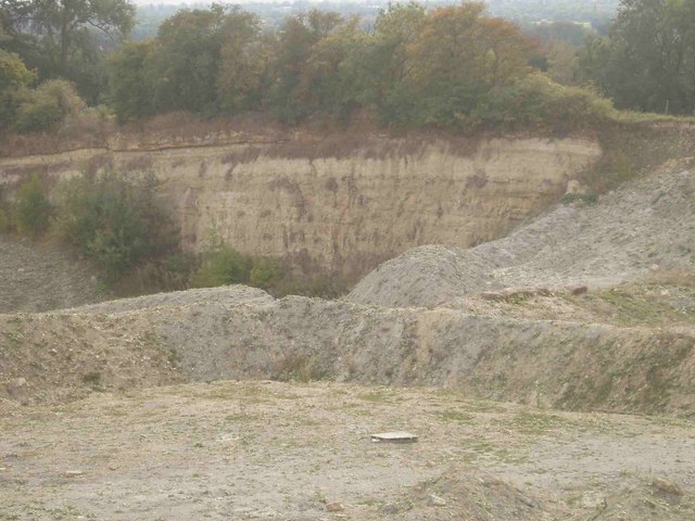 Woodeaton Quarry
 Woodeaton Quarry
| Type | Subtype | Date | Description | Notes | Source |
|---|---|---|---|---|---|
| classes | subterranea | 1960 | Northern Mine Research Society | nonprofit organization, subterranea, charitable organization, learned society, mining history | Wikidata |
| site | bunker | Aylesbury Buckinghamshire County Emergency Centre | Buckinghamshire County Council, civil defense center | Wikidata | |
| site | bunker | Banbury Cherwell District Council Emergency Centre | Cherwell District Council, civil defense center | Wikidata | |
| site | bunker | Oxford County Emergency Centre | civil defense center, Oxford City Council | Wikidata | |
| site | bunker | Oxford Royal Observer Corps Group Headquarters | Royal Observer Corps, Royal Observer Corps Group Headquarters, bunker | Wikidata | |
| site | bunker | Oxfordshire County Emergency Centre | Oxfordshire County Council, civil defense center | Wikidata | |
| site | bunker | Witney West Oxfordshire Emergency Centre | West Oxfordshire District Council, civil defense center | Wikidata | |
| site | cave | Grotto And Rockery Approximately 40 Metres South Of Temple Of Flora | grotto | Wikidata | |
| site | cave | Grotto Approximately 4 Metrres West Of The Cold Bath | grotto | Wikidata | |
| site | cave | Grotto By Lake C250 Metres North East Of Eythrope Pavilion | grotto | Wikidata | |
| site | cave | The Grotto | grotto | Wikidata | |
| site | mine | Ardley Cutting and Quarry | quarry | Wikidata | |
| site | mine | Bugle Quarry | quarry | Wikidata | |
| site | mine | Coombs Quarry | quarry | Wikidata | |
| site | mine | Kirtlington Quarry | quarry | Wikidata | |
| site | mine | Lyehill Quarry | quarry | Wikidata | |
| site | mine | Shellingford Crossroads Quarry | quarry | Wikidata | |
| site | mine | Woodeaton Quarry | quarry | Wikidata | |
| site | tunnel | Ardley Tunnel | railway tunnel | Wikidata | |
| site | tunnel | Brill Tunnel | railway tunnel | Wikidata | |
| site | tunnel | Wolvercote Tunnel | railway tunnel | Wikidata | |
| commons | image | Woodeaton Quarry | Commons | ||
| commons | image | Woodeaton Quarry | Commons | ||
| commons | image | Woodeaton Quarry | Commons | ||